Toronto streetcar system

Toronto streetcar in May 2009.
|
|||
| Overview | |||
|---|---|---|---|
| Locale | Toronto, Ontario, Canada | ||
| Transit type | Streetcar | ||
| Number of lines | 11 | ||
| Number of stations | 685 stops, including 8 shared with the subway (all others but one are street-level stops) | ||
| Daily ridership | 291,000 (avg. weekday, Q2 2014) |
||
| Annual ridership | 100,037,500 (2013) | ||
| Operation | |||
| Began operation | 1861 (electric lines since 1892) | ||
| Operator(s) | Toronto Transit Commission | ||
| Character | Street running | ||
| Technical | |||
| System length | 83 km (52 mi) | ||
| Track gauge | 4 ft 10 7⁄8 in (1,495 mm) Toronto gauge | ||
| Minimum radius of curvature | 36 ft 0 in (10,973 mm) | ||
| Electrification | Overhead lines, 600 V DC | ||
|
|||
The Toronto streetcar system is a network of eleven streetcar routes in Toronto, Ontario, Canada, operated by the Toronto Transit Commission (TTC). It is both the largest and busiest light-rail system in North America as well as the largest tramway in the Americas in terms of ridership, number of cars, and track length. The network is concentrated primarily in Downtown Toronto and in proximity to the city's waterfront. Much of the streetcar route network dates to the 19th century. Most of Toronto's streetcar routes operate on street trackage shared with vehicular traffic, and streetcars stop on demand at frequent stops like buses. Some routes operate wholly or partly within their own rights-of-way, and stop on demand at frequent stops.
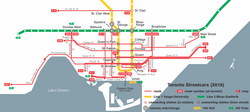
There are underground connections between streetcars and the subway at St. Clair West, Spadina, and Union stations, and streetcars enter St. Clair, Dundas West, Bathurst, Broadview, and Main Street stations at street level. At the eight downtown stations, excepting Union, from Queen's Park to College on Line 1 Yonge–University, streetcars stop on the street outside the station entrances.
...
Wikipedia

