Torne älv
| Torne | |
| Tornionjoki, Torne älv, Torneälven, Duortneseatnu, Tornionväylä |
|
| River | |
|
The Torne at Tornio
|
|
| Countries | Sweden, Finland, Norway (hydrological source) |
|---|---|
| Source | Torne träsk and its main affluent |
| - location | Kiruna Municipality, Norrbotten, Sweden |
| - elevation | 341 m (1,119 ft) (hydrological source 1189 m 65°48′30″N 24°8′45″E / 65.80833°N 24.14583°E) |
| - coordinates | 68°22′N 019°06′E / 68.367°N 19.100°E |
| Mouth | Gulf of Bothnia |
| - location | Tornio/Haparanda, Finland/Sweden |
| - elevation | 0 m (0 ft) |
| - coordinates | 65°50′N 024°09′E / 65.833°N 24.150°ECoordinates: 65°50′N 024°09′E / 65.833°N 24.150°E |
| Length | 510 km (317 mi) plus 110 km above the outlet of Torneträsk |
| Basin | 40,157.1 km2 (15,505 sq mi) |
| Discharge | |
| - average | 370 m3/s (13,066 cu ft/s) |
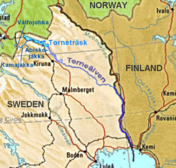
The Torne, also known as the Tornio (Finnish: Tornionjoki, Swedish: Torne älv, Torneälven, Northern Sami: Duortneseatnu, Meänkieli: Tornionväylä), is a river in northern Sweden and Finland. For approximately half of its length it contains the border between these two countries. It rises at Lake Torne (Swedish: Torneträsk) near the border with Norway and flows generally southeast for a distance of 522 kilometres (324 mi) into the Gulf of Bothnia. It is the largest river in Norrbotten both by length and by watershed area.
The Torne basin has a total area of 37,300 square kilometres (14,400 sq mi) or 40,147.1 square kilometres (15,500.9 sq mi) (see sidebar). Of this, 25,392.2 km2 (9,804.0 sq mi) or 25,393.1 km2 (9,804.3 sq mi) is in Sweden, 10,400 km2 (4,000 sq mi) or 14,266.3 km2 (5,508.2 sq mi) is in Finland and 1,500 km2 (580 sq mi) or 497.7 km2 (192.2 sq mi) is in Norway.
The source of the Torne is generally believed to be Lake Torne (Swedish: Torneträsk) near the border with Norway. But the main feeder of this lake is Abiskojåkka, flowing out of Abiskojaure, which is mainly fed by Kamajåkka, coming from Lake Gamajávri. This lake's major tributary is Válfojohka. That river comes from Lake Válfojávri in Norway's Nordland Fylke, but near to that lake it is joined by a nameless, longer stream, according to official Swedish maps fed by a small glacier, 1189 metres above sea level (68°16′02″N 18°07′41″E / 68.26722°N 18.12806°E).
...
Wikipedia


