Tongala
|
Tongala Victoria |
|
|---|---|

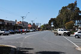
Mangan St, the main street of Tongala
|
|
| Coordinates | 36°15′0″S 144°57′0″E / 36.25000°S 144.95000°ECoordinates: 36°15′0″S 144°57′0″E / 36.25000°S 144.95000°E |
| Population | 1,869 (2011 census) |
| Postcode(s) | 3621 |
| Location |
|
| LGA(s) | Shire of Campaspe |
| State electorate(s) | Murray Plains |
| Federal Division(s) | Murray |
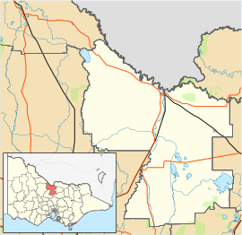
Tongala /təŋˈɡɑːlə/ is a town in the Goulburn Valley region of northern Victoria, Australia. The town is in the Shire of Campaspe local government area, between Kyabram and Echuca, 225 kilometres (140 mi) north of the state capital, Melbourne. At the 2011 census, Tongala had a population of 1,869.
The first Post Office in the area opened on 27 April 1878. In 1882 it was renamed Kanyapella and a new Tongala office opened to the south; this was renamed Tongala East in 1908 when a new Tongala office replaced the Tongala Railway Station office in the township.
St Patrick's Catholic church was constructed in 1909, opening on Sunday 28 November 1909. St Patrick's Catholic primary school was opened in 1959.
The Tongala water tower, designed by John Monash, was constructed in 1914 with an initial capacity of 10,000 imperial gallons (45,000 l) and extended to 20,000 imperial gallons (91,000 l) in 1923.
After World War I many blocks were opened up under the 'soldier-settler' scheme. One such soldier settler was John McEwen— later Prime Minister of Australia—who bought a block at Tongala and married a local, Anne McLeod, in the town in 1921.
In November 2003 a monument to the 24 Australian Light horse regiments and their horses was unveiled by Maurice Watson, aged 84 the last Light Horseman, who enlisted from Tongala. The statue, standing two metres, is of a horseman carrying an empty saddle, bridle and saddle cloth, walking away, head lowered.
...
Wikipedia

