Tolmin
| Tolmin | |
|---|---|
| Town | |

Tolmin
|
|
| Location of the town of Tolmin in Slovenia | |
| Coordinates: 46°11′8.69″N 13°44′6.54″E / 46.1857472°N 13.7351500°ECoordinates: 46°11′8.69″N 13°44′6.54″E / 46.1857472°N 13.7351500°E | |
| Country |
|
| Traditional region | Slovenian Littoral |
| Statistical region | Gorizia |
| Municipality | Tolmin |
| Government | |
| • Mayor | Uroš Brežan |
| Area | |
| • Total | 1.7 km2 (0.7 sq mi) |
| Population (2012) | |
| • Total | 3,525 |
| • Density | 1,284/km2 (3,330/sq mi) |
| Time zone | CET (UTC+01) |
| • Summer (DST) | CEST (UTC+02) |
| Climate | Cfb |
| Website | www |
Tolmin (pronounced [tɔlˈmiːn]; Italian: Tolmino,German Tolmein) is a small town in northwestern Slovenia. It is the administrative centre of the Municipality of Tolmin.
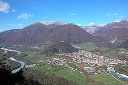
Tolmin is situated on the southern rim of the Julian Alps, the largest settlement in the Upper Soča Valley (Slovene: Zgornje Posočje), close to the border with Italy. It is located on a terrace above the confluence of the Soča and Tolminka rivers, positioned beneath steep mountainous valleys. The old town gave its name to the entire Tolmin area (Slovene: Tolminsko) as its economic, cultural and administrative centre.
The area is located in the historic Goriška region, itself part of the larger Slovene Littoral, about 41 km (25 mi) north of Nova Gorica and 87 km (54 mi) west of the Slovene capital Ljubljana. In the north, the road leads further up the Soča River to Bovec, with an eastern branch-off to Škofja Loka and Idrija.
Early inhabitants were Illyrians in Tolmin area. It was ruled successively by Roman Empire, Odoacker, Ostrogoths, Eastern Rome Empire and part of the Lombard Duchy of Friuli until it was conquered by the Frankish king Charlemagne in 774 and replaced by the Carolingian March of Friuli.
...
Wikipedia

