Tokyo Bay Aqua-Line
|
Tokyo Bay Aqua-Line 東京湾アクアライン |
|
|---|---|

Tokyo Bay Aqua-Line (bridge section)
|
|
| Coordinates | 35°27′47″N 139°52′31″E / 35.46306°N 139.87528°ECoordinates: 35°27′47″N 139°52′31″E / 35.46306°N 139.87528°E |
| Carries | 4 lanes of |
| Crosses | Tokyo Bay |
| Locale | |
| Other name(s) | Trans-Tokyo Bay Highway |
| Characteristics | |
| Design |
|
| Total length |
|
| Width | 22.9 metres (75 ft) |
| Longest span | 240 metres (787 ft) |
| Piers in water | 42 |
| Clearance below | 29 metres (95 ft) |
| History | |
| Fabrication by |
|
| Construction begin | 1989 |
| Construction cost | ¥1.4 trillion |
| Opened | 18 December 1997 |

Umihotaru, where bridge transitions to tunnel
|
|
| Overview | |
|---|---|
| Status |
|
| Start | Umihotaru Island |
| End | Ukishima, Kawasaki, Kanagawa |
| Operation | |
| Constructed | Taisei |
| Technical | |
| Number of lanes | 2 (unidirectional) in each of 2 tunnels |
| Highest elevation | sea level |
| Lowest elevation | −45 metres (−148 ft) |
| Width |
|
| Grade | 4% |
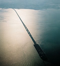
The Tokyo Bay Aqua-Line (東京湾アクアライン Tōkyō-wan Akua-rain?), also known as the Trans-Tokyo Bay Highway, is a bridge–tunnel combination across Tokyo Bay in Japan. It connects the city of Kawasaki in Kanagawa Prefecture with the city of Kisarazu in Chiba Prefecture, and forms part of National Route 409. With an overall length of 14 km, it includes a 4.4 km bridge and 9.6 km tunnel underneath the bay—the fourth-longest underwater tunnel in the world.
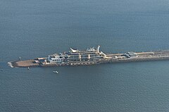
At the bridge–tunnel crossover point, there is an artificial island called Umihotaru (海ほたる Umi-hotaru?, literally meaning "sea firefly") with a rest area consisting of restaurants, shops and amusement facilities. Air is supplied to the tunnel by a distinctive tower in the middle of the tunnel, called the Kaze no Tō (風の塔, "the tower of wind"), which uses the bay's almost-constant winds as a power source.
The road opened on December 18, 1997 after 23 years of planning and 9 years of construction at a cost of 1.44 trillion yen (11.2 billion USD at the time of opening).
The Tokyo Bay Aqua-Line reduced the drive between Chiba and Kanagawa, two important industrial regions, from 90 to 15 minutes, and also contributed to cutting the travel time to the sea leisure area in the southern part of the Bōsō Peninsula from Tokyo and Kanagawa. Before the tunnel opened, one had to drive around about 100 km along the shores of Tokyo Bay and pass through downtown Tokyo.
...
Wikipedia

