Tokunoshima
| Native name: 徳之島, Tokunoshima Tukunushima |
|
|---|---|

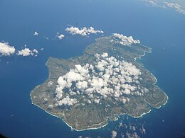
Aerial view of the island. (2011)
|
|
| Geography | |
| Location | East China Sea |
| Coordinates | 27°49′12″N 128°55′56″E / 27.82000°N 128.93222°ECoordinates: 27°49′12″N 128°55′56″E / 27.82000°N 128.93222°E |
| Archipelago | Amami Islands |
| Area | 247.77 km2 (95.66 sq mi) |
| Length | 25 km (15.5 mi) |
| Width | 18 km (11.2 mi) |
| Coastline | 80 km (50 mi) |
| Highest elevation | 645 m (2,116 ft) |
| Highest point | Inokawadake |
| Administration | |
|
Japan
|
|
| Prefectures | Kagoshima Prefecture |
| District | Ōshima District |
| Demographics | |
| Population | 27,000 (2013) |
| Pop. density | 108.97 /km2 (282.23 /sq mi) |
| Ethnic groups | Japanese |
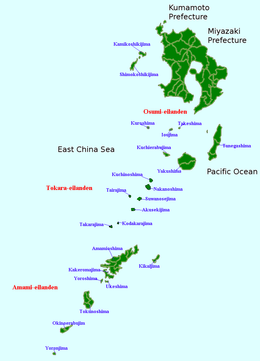
Tokunoshima (Japanese: 徳之島?, Amami: トゥクヌシマ, Tukunushima), also known in English as Tokunoshima Island and Tokuno Island, is one of the Satsunan Islands, classed with the Amami archipelago between Kyūshū and Okinawa.
The island, 247.77 km2 (95.66 sq mi) in area, has a population of approximately 27,000. Administratively it is divided into the three towns of Tokunoshima, Isen, and Amagi in Kagoshima Prefecture. Much of the island is within the borders of the Amami Guntō Quasi-National Park.
Tokunoshima is isolated from the other Amami islands, and is located halfway between Amami Oshima and Okinoerabujima, approximately 489 kilometers (264 nmi) south of the southern tip of Kyūshū and 100 kilometres (54 nmi) north of Okinawa.
The island is of volcanic origin with a length of approximately 25 kilometers (16 mi) and width of 18 kilometers (11 mi), with Mount Inokawadake at 645 meters (2,116 ft) above sea level at its highest peak. Mount Amagidake in the north has a height of 533 meters (1,749 ft). The coast of the island is surrounded by a coral reef.
The island is covered with forests of laurel, but has been extensively cleared for agriculture. There are many caves on the island, the longest of which measures 2,052 meters (6,732 ft) and is located in the area of Isen.
...
Wikipedia

