Amami Islands

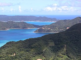
Coast of Amami Oshima
|
|
| Map of the Amami Islands | |
| Geography | |
|---|---|
| Coordinates | 28°16′N 129°21′E / 28.267°N 129.350°E |
| Adjacent bodies of water | Pacific Ocean |
| Total islands | 8 (inhabited) |
| Highest elevation | 694 m (2,277 ft) |
| Highest point | Yuwandake |
| Administration | |
|
Japan
|
|
| Prefectures | Kagoshima |
| Demographics | |
| Population | 121,266 (2008) |
| Ethnic groups | Ryukyuan, Japanese |
The Amami Islands (奄美群島 Amami-guntō?) is an archipelago in the Satsunan Islands, which is in turn part of the Ryukyu Islands. Administratively, the group belongs to Kagoshima Prefecture, Japan. The Geospatial Information Authority of Japan and the Japan Coast Guard agreed on February 15, 2010, to use the name of Amami-guntō (奄美群島?) for the Amami Islands. Prior to that, Amami-shotō (奄美諸島?) was also used. The name of Amami is probably cognate with Amamikyu (阿摩美久?), the goddess of creation in the Ryukyuan creation myth.
The Amami Islands are limestone islands of coralline origin and have a total area of approximately 1,240.28 square kilometres (478.87 sq mi). The highest elevation is Yuwandake with a height of 694 metres (2,277 ft) on Amami Ōshima. The climate is a humid subtropical climate (Köppen climate classification Cfa) with very warm summers and mild winters. Precipitation is high throughout the year, but is highest in the months of May, June and September. The area is subject to frequent typhoons.
...
Wikipedia

