Titov Vrbas
|
Vrbas Врбас |
|||
|---|---|---|---|
| Town and municipality | |||
 |
|||
|
|||
 Location of the municipality of Vrbas within Serbia |
|||
| Coordinates: 45°34′N 19°39′E / 45.567°N 19.650°ECoordinates: 45°34′N 19°39′E / 45.567°N 19.650°E | |||
| Country |
|
||
| Province | Vojvodina | ||
| District | South Bačka | ||
| Settlements | 7 | ||
| Government | |||
| • Mayor | Željko Vidović | ||
| Area | |||
| • Municipality | 376 km2 (145 sq mi) | ||
| Population (2011 census) | |||
| • Town | 24,112 | ||
| • Municipality | 42,092 | ||
| Time zone | CET (UTC+1) | ||
| • Summer (DST) | CEST (UTC+2) | ||
| Postal code | 21460 | ||
| Area code | +381 21 | ||
| Car plates | VS | ||
| Website | www |
||
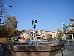
Vrbas (Serbian Cyrillic: Врбас, Hungarian: Verbász) is a town and municipality located in the South Bačka District of the autonomous province of Vojvodina, Serbia. In 2011 the city had a total population of 24,112, while the municipality had 42,092.
Its name stems from the word "Willow" in the Serbian language. During the SFRY period, the town was renamed Titov Vrbas (meaning "the Vrbas of Tito"), after Josip Broz Tito. Like all other towns in Socialist Yugoslavia named after Tito, the first part was dropped once the new states were formed during the early 1990s.
In Rusyn, the town is known as Вербас, in Hungarian as Verbász, in Croatian as Vrbas, in German as Werbass, and in Turkish as Verbas.
Vrbas was mentioned first in 1213 during the administration of the Kingdom of Hungary. According to other sources, it was mentioned first in 1387. In the 16th century it became a part of the Ottoman Empire. During Ottoman administration it was populated by ethnic Serbs.
Since the Treaty of Passarowitz (1718), Vrbas and the Banat were placed under administration of the Habsburg Monarchy. According to the 1720 census, it was populated exclusively by Serbs (about 250 families).
After 1784 many Germans settled in the town founding a new settlement named Novi Vrbas (Neu-Verbasz) near the old Serb settlement, which then became known as Stari Vrbas (Old Vrbas).
...
Wikipedia


