Tirari Desert
| Tirari | |
| Desert | |
|
NASA satellite image, 2006
|
|
| Country | Australia |
|---|---|
| State | South Australia |
| Region | Far North |
| Area | 15,250 km2 (5,888 sq mi) |
| Biome | Desert |
|
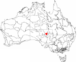
This is a map of the Interim Biogeographic Regionalisation of Australia (IBRA), with state boundaries overlaid. The Tirari Desert region is shown in red.
|
|
The Tirari Desert is a 15,250 square kilometres (5,888 sq mi)desert in the eastern part of the Far North region of South Australia.
The Tirari Desert features salt lakes and large north-south running sand dunes. It is located partly within the Kati Thanda-Lake Eyre National Park. It lies mainly to the east of Lake Eyre North. Cooper Creek runs through the centre of the desert.
The adjacent deserts of the area include Simpson Desert which lies to the north while the Strzelecki Desert is to the east and the Sturt Stony Desert runs aligned with the Birdsville track to the north east.
The desert experiences harsh conditions with high temperatures and very low rainfall (mean annual rainfall is below 125 millimetres (4.9 in)).
The main vehicular access to the desert is via the unpaved Birdsville Track which runs northwards from Marree to Birdsville. The Mungerannie Hotel is the only location between the two towns that provides services.
The Tirari Desert region has a number of large cattle stations which are stopping points on the Channel Country aviation mail run.
Dulkaninna Station has been run by the same family for 110 years, has 2,000 cattle and breeds horses and kelpies.Etadunna Station to the north is a 1-million-acre (4,000 km2) cattle station with 2500 cattle. The station environs include a number of heritage sites include Bucaltaninna Homestead ruins, the Woolshed ruins and Canny Trig Point (also known as Milner's Pile) and the state heritage-registered Killalpaninna Mission site.
...
Wikipedia


