Tinmouth, Vermont
| Tinmouth, Vermont | |
|---|---|
| Town | |

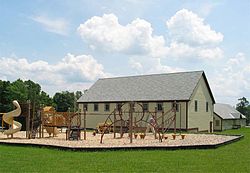
Community center and elementary school in Tinmouth
|
|
 Tinmouth, Vermont |
|
| Coordinates: 43°26′54″N 73°3′3″W / 43.44833°N 73.05083°W | |
| Country | United States |
| State | Vermont |
| County | Rutland |
| Chartered | 1761 |
| Area | |
| • Total | 28.4 sq mi (73.6 km2) |
| • Land | 28.3 sq mi (73.3 km2) |
| • Water | 0.1 sq mi (0.3 km2) |
| Elevation | 1,371 ft (418 m) |
| Population (2010) | |
| • Total | 613 |
| • Density | 22/sq mi (8.3/km2) |
| Time zone | Eastern (EST) (UTC-5) |
| • Summer (DST) | EDT (UTC-4) |
| ZIP code | 05773 |
| Area code(s) | 802 |
| FIPS code | 50-72925 |
| GNIS feature ID | 1462227 |
Coordinates: 42°26′54″N 73°3′3″W / 42.44833°N 73.05083°W Tinmouth is a town in Rutland County, Vermont, United States. The population was 613 at the 2010 census.
Tinmouth was established in 1761 in a region that came to be known as the New Hampshire Grants. At the first U.S. census, the town had a population of 935. Tinmouth's population peaked in 1820, and for the next 150 years the town's population gradually declined, reaching its lowest (268) in 1970. The town reached a population of 567 at the 2000 census, the first time since the 1880 census that it was above 500.
In early 2007 the citizens of Tinmouth undertook what turned into an "acrimonious" debate about switching from town meeting to the Australian ballot; two separate votes were held, both close, but ending in the decision to make the switch. The first vote was 97–95 in favor of the switch, the second was 112–104.
According to the United States Census Bureau, the town has a total area of 28.4 square miles (74 km2), of which 28.3 square miles (73 km2) is land and 0.1 square miles (0.26 km2), or 0.42%, is water.
...
Wikipedia
