Tiefenbach (Hunsrück)
| Tiefenbach | ||
|---|---|---|
|
||
| Coordinates: 49°56′17″N 7°32′44″E / 49.93806°N 7.54556°ECoordinates: 49°56′17″N 7°32′44″E / 49.93806°N 7.54556°E | ||
| Country | Germany | |
| State | Rhineland-Palatinate | |
| District | Rhein-Hunsrück-Kreis | |
| Municipal assoc. | Simmern | |
| Government | ||
| • Mayor | Klaus Imig | |
| Area | ||
| • Total | 5.79 km2 (2.24 sq mi) | |
| Elevation | 361 m (1,184 ft) | |
| Population (2015-12-31) | ||
| • Total | 734 | |
| • Density | 130/km2 (330/sq mi) | |
| Time zone | CET/CEST (UTC+1/+2) | |
| Postal codes | 55471 | |
| Dialling codes | 06761 | |
| Vehicle registration | SIM | |
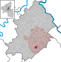
Tiefenbach is an Ortsgemeinde – a municipality belonging to a Verbandsgemeinde, a kind of collective municipality – in the Rhein-Hunsrück-Kreis (district) in Rhineland-Palatinate, Germany. It belongs to the Verbandsgemeinde of Simmern, whose seat is in the like-named town. Today’s Tiefenbach grew together from two centres named Untertiefenbach and Obertiefenbach.
The municipality lies in the Hunsrück roughly 5 km south of Simmern and 9 km east of Kirchberg. To the east and south lies the Soonwald, a heavily wooded section of the west-central Hunsrück.
Tiefenbach’s early history is linked with the Wildburg (castle), which had its first documentary mention in 1253. Later, Tiefenbach, which lay at the northern foot of the Soonwald, was part of Palatinate-Simmern, which in 1556 introduced the Reformation. In 1673, the village passed to the Electorate of the Palatinate. Beginning in 1794, Tiefenbach lay under French rule. In 1815 it was assigned to the Kingdom of Prussia at the Congress of Vienna. In 1912, a Catholic chapel was built. After the First World War, the village was once again occupied by the French for a time. In the 1930s, the local ore mine, “Märkerei”, was shut down. Since 1946, Tiefenbach has been part of the then newly founded state of Rhineland-Palatinate. In 1961, the Evangelical church was built.
...
Wikipedia


