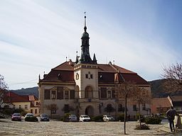
Tišnov
| Tišnov | |||
| Town | |||
|
Town Hall
|
|||
|
|||
| Country | Czech Republic | ||
|---|---|---|---|
| Region | South Moravian | ||
| District | Brno-Country | ||
| Commune | Tišnov | ||
| Rivers | Svratka, Loučka | ||
| Elevation | 256 m (840 ft) | ||
| Coordinates | 49°20′N 16°25′E / 49.333°N 16.417°ECoordinates: 49°20′N 16°25′E / 49.333°N 16.417°E | ||
| Area | 17.13 km2 (6.61 sq mi) | ||
| Population | 8,984 (2015) | ||
| Density | 524/km2 (1,357/sq mi) | ||
| First mentioned | 1233 | ||
| Mayor | Bc. Jiří Dospíšil | ||
| Timezone | CET (UTC+1) | ||
| - summer (DST) | CEST (UTC+2) | ||
| Postal code | 666 01 | ||
| Statistics: statnisprava.cz | |||
| Website: www.tisnov.cz | |||
Tišnov (Czech pronunciation: [ˈcɪʃnof]; German: Tischnowitz) is a town in the Czech Republic. Tišnov is a town in the Brno-Country District of the South Moravian Region, 22 km northwest of Brno, near the confluence of the Svratka and Loučka rivers. In 2010 there were 8,704 inhabitants.
The first recorded mention of Tišnov (then using the name Tušnovice) is found in a charter of 1233 about the Cistercian convent Porta Coeli, which was founded three years earlier by Constance of Hungary. The founding of the monastery was also supported by her two sons, Moravian Margrave Přemysl and King Wenceslaus I. The property remained a monastery until its dissolution in 1782.
In 1416, King Wenceslas IV granted the town the right to hold an annual market. The city was burned during the Hussite battles in 1428 and remained spared from damage in the Thirty Years War.
After being named as Tischnowitz or Tischnovitz, the town became known as Tišnov, and was included in Brno-area district in 1869. A railway line connecting Tišnov to Brno was constructed in 1885, and twenty years later the track was extended to Havlíčkův Brod, by which time Tišnov was its own municipality.
Until 1918, Tišnov was a part of the Austrian monarchy (Austria side after the compromise of 1867), in the district with the same name, one of the 34 Bezirkshauptmannschaften in Moravia.
...
Wikipedia


