Thurston County, Nebraska
| Thurston County, Nebraska | |
|---|---|

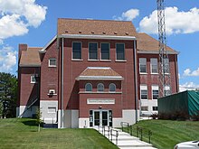
Thurston County courthouse in Pender
|
|
 Location in the U.S. state of Nebraska |
|
 Nebraska's location in the U.S. |
|
| Founded | 1889 |
| Named for | John Mellen Thurston |
| Seat | Pender |
| Largest village | Pender |
| Area | |
| • Total | 396 sq mi (1,026 km2) |
| • Land | 394 sq mi (1,020 km2) |
| • Water | 2.5 sq mi (6 km2), 0.6% |
| Population | |
| • (2010) | 6,940 |
| • Density | 18/sq mi (7/km²) |
| Congressional district | 1st |
| Time zone | Central: UTC-6/-5 |
Thurston County is a county in the U.S. state of Nebraska. As of the 2010 census, the population was 6,940. Its county seat is Pender.
In the Nebraska license plate system, Thurston County is represented by the prefix 55 (it had the 55th-largest number of vehicles registered in the county when the license plate system was established in 1922).
The Siouan-speaking Omaha and smaller Winnebago Tribe of Nebraska (Ho-Chunk) each have reservations in Thurston County. Together, the two reservations officially comprise the county's entire land area.
Varying cultures of indigenous peoples lived along the rivers for thousands of years before European encounter. The Omaha occupied this territory and much of Nebraska and western Iowa before the Europeans arrived. They had migrated west from the Ohio Valley under pressure from the Iroquois Confederacy in the early 17th century.
Thurston County was organized by European Americans in 1889 from land that had been divided between Dakota and Burt counties since the dissolution of Blackbird County in 1879. It was named after the United States Senator John M. Thurston.
According to the U.S. Census Bureau, the county has a total area of 396 square miles (1,030 km2), of which 394 square miles (1,020 km2) is land and 2.5 square miles (6.5 km2) (0.6%) is water. The land area of the county is completely comprised from the Omaha and Winnebago Indian reservations.
...
Wikipedia
