Three Pagodas Pass
| Three Pagodas Pass | |
|---|---|

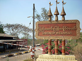
Burmese-Thai border checkpoint, Three Pagodas Pass
|
|
| Elevation | 282 m (925 ft) |
| Location | Burma–Thailand border |
| Range | Tenasserim Hills |
| Coordinates | 15°18′6″N 98°24′7″E / 15.30167°N 98.40194°ECoordinates: 15°18′6″N 98°24′7″E / 15.30167°N 98.40194°E |
|
Location of the Three Pagodas Pass in Thailand, on the border with Burma
|
|
Three Pagodas Pass (Burmese: ဘုရားသုံးဆူ တောင်ကြားလမ်း, Burmese pronunciation: [pʰajá θóʊɴ zù tàʊɴ dʑá láɴ]; Thai: ด่านเจดีย์สามองค์, rtgs: Dan Chedi Sam Ong, Thai pronunciation: [dàːn tɕeːdiː sǎːm ʔoŋ]) is a pass in the Tenasserim Hills on the border between Thailand and Burma (Myanmar), at an elevation of 282 metres (925 ft). The pass links the town of Sangkhla Buri in the north of Kanchanaburi Province, Thailand, to the town of Payathonsu in the south of Kayin State, Myanmar.
The pass is named after three small, crumbling stupas or chedis which were probably built at the end of Ayutthaya period as a symbol of peace. They are now on the Thai side of the border. Parts of the border are still disputed. These three chedis appear in the provincial seal of Kanchanaburi Province in stylized form. The pass gives its name to the Three Pagodas Fault.
This pass has been the main land route into western Thailand since ancient times, and is believed be the point at which Buddhist teachings reached the country from India in the 3rd century.
...
Wikipedia

