Thrakomakedones
|
Thrakomakedones Θρακομακεδόνες |
|
|---|---|
| Coordinates: 38°7′N 23°45′E / 38.117°N 23.750°ECoordinates: 38°7′N 23°45′E / 38.117°N 23.750°E | |
| Country | Greece |
| Administrative region | Attica |
| Regional unit | East Attica |
| Municipality | Acharnes |
| • Municipal unit | 3.550 km2 (1.371 sq mi) |
| Elevation | 360 m (1,180 ft) |
| Population (2011) | |
| • Municipal unit | 6,200 |
| • Municipal unit density | 1,700/km2 (4,500/sq mi) |
| Time zone | EET (UTC+2) |
| • Summer (DST) | EEST (UTC+3) |
| Postal code | 136 76 |
| Area code(s) | 210 243 |
| Vehicle registration | Z |
| Website | www.thrakomakedones.gr |
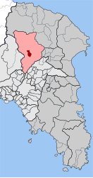
Thrakomakedones (Greek: Θρακομακεδόνες from Thrace and Macedonia), is a town in the regional unit East Attica, in Attica region, Greece. It is a northern suburb of Athens. Since the 2011 local government reform it is part of the municipality Acharnes, of which it is a municipal unit. The municipal unit has an area of 3.550 km2.
Thrakomakedones is situated in the southern foothills of the Parnitha mountains, at the northern edge of the Athens conurbation. It is 5 km northeast of Acharnes and 16 km north of Athens city centre. The 1999 Athens earthquake also affected Thrakomakedones, causing severe damage to several houses and a school.
...
Wikipedia


