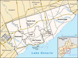
The Queensway – Humber Bay
| The Queensway – Humber Bay | |
|---|---|
| Neighbourhood | |

Condominium towers along the south side of Lake Shore Boulevard (development of former Motel Strip)
|
|
| Location within Toronto | |
| Coordinates: 43°37′49″N 79°29′03″W / 43.63028°N 79.48417°WCoordinates: 43°37′49″N 79°29′03″W / 43.63028°N 79.48417°W | |
| Country |
|
| Province |
|
| City |
|
| Community | Etobicoke-York |
| Established | 1883 (Subdivision) 1890 (Postal village) 'Humber' 1890 (Postal village) 'Queensway' |
| Changed Municipality | 1998 Toronto from Etobicoke |
| Government | |
| • MP | James Maloney (Etobicoke—Lakeshore) |
| • MPP | Peter Milczyn (Etobicoke—Lakeshore) |
| • Councillor | Justin Di Ciano (Ward 5 Etobicoke—Lakeshore) |
The Queensway – Humber Bay, known officially as Stonegate-Queensway, is a neighbourhood in the south-west of Toronto, Ontario, Canada. It is located in the south-east of the former City of Etobicoke.
This neighbourhood originally centred on the intersection of Lake Shore Boulevard and The Queensway near the mouth of the Humber River, however that intersection disappeared with the building of the Queen Elizabeth Way. The area to the south of the Gardiner Expressway is today part of Mimico neighbourhood. Today, the neighbourhood is composed of two areas which overlap at the former intersection:
This community is mainly made up of 1950s era low-rise apartment buildings and an old turn-of-the century market garden community was absorbed by the city as it grew. There is little traffic, and the only amenities in the area are in the Stonegate Plaza, which include delis, dollar stores, a pharmacy, a laundromat, and a Valu-Mart. The southeast portion of the neighbourhood is relatively low-rent, with a high population of European immigrants.
Most streets formerly south of The Queensway east of the Mimico Creek were lost when the QEW was built. However, along the waterfront, a new street has been built on largely artificial shoreline named Marine Parade after a similar 1890s street planned to run along Mimico's shoreline. Some streets laid out in developments for returning soldiers carry names commemorating military men such as: Hornell (war hero born in Mimico), Saunders, Clive and Cochrane (formerly Churchill). Other streets laid out in the following years celebrate the coronation of Queen Elizabeth II such as: The Queensway and Lillibet Rd. Many streets in the Stonegate neighbourhood north of Berry Road are entirely new, such as: Sunnydale, Kinsdale and Heatherdale.
After the fall of New France to the British, a French trader and first Toronto settler M. Rousseau received permission from the British administration to settle with his family on the site of the second French Fort in Toronto (at the foot of the Humber River). When the Simcoes arrived from Newark (Niagara-on-the-Lake) with several hundred Queen's Rangers (Loyalist soldiers), M. Rousseau guided the ships into Toronto Bay (now Toronto Inner Harbour).John Graves Simcoe renamed the Toronto River the Humber after the Humber River in England. When land in the area was surveyed and divided into lots, the area on both side of the Humber River was reserved by the government for timber and M. Rousseau was offered land on the west (Etobicoke) side in what is now the Humber Bay neighbourhood. M. Rousseau refused to relocate from one side of the river and he left to resettle near Hamilton where he was given land in compensation. The Kings Mill Reserve was that part of the original forest that covered Toronto that was preserved rather than cleared for farms. The Kings Mill (Old Mill) is at Bloor north of this neighbourhood but the reserve stretched south to what is now the Queensway covering most of modern Humber Bay's residential district. The Kings Mill reserve was commemorated in this neighbourhood by the Kitzler Vocational Collegiate (now Bishop Allen Academy) which was actually on the west side of the Mimico Creek in The Queensway.
...
Wikipedia

