The Maritimes
| The Maritimes | |
| Region | |
|
Peggys Cove, Nova Scotia, an archetypal classic Maritime scene
|
|
| Country | |
|---|---|
| Provinces | |
| Area | 132,416 km2 (51,126 sq mi) |
| Population | 1,813,102 (2011) |
| Density | 14/km2 (36/sq mi) |
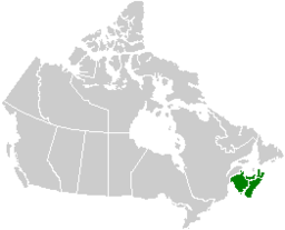
The Maritimes, also called the Maritime provinces or the Canadian Maritimes, is a region of Eastern Canada consisting of three provinces: New Brunswick, Nova Scotia, and Prince Edward Island. The Maritimes had a population of 1,813,102 in 2011.
The Maritimes, along with a fourth province – Canada's easternmost province, Newfoundland and Labrador – make up Atlantic Canada.
Located along the Atlantic coast, various aquatic sub-basins are located in the Maritimes, such as the Gulf of Maine and Gulf of St. Lawrence. The region is located northeast of New England, southeast of Quebec's Gaspé Peninsula, and southwest of the island of Newfoundland.
The notion of a Maritime Union has been proposed at various times in Canada's history; the first discussions in 1864 at the Charlottetown Conference contributed to Canadian Confederation which instead formed the larger Dominion of Canada.
The Mi'kmaq, Maliseet and Passamaquoddy people are indigenous to the Maritimes, while Acadian and British settlements date to the 17th century.
...
Wikipedia


