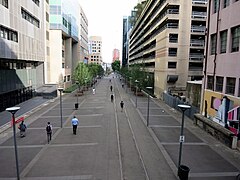
The Goods Line
| The Goods Line | |
|---|---|

The original section of The Goods Line in November 2016
|
|
| Type | urban linear park; public park |
| Location | Sydney, Australia |
| Coordinates | 40°44′54″N 74°0′18″W / 40.74833°N 74.00500°W |
| Operated by | Sydney Harbour Foreshore Authority |
| Status | Open |
The Goods Line is a linear park and pedestrian pathway approximately 500 metres long in the Sydney suburb of Ultimo. The corridor connects Railway Square to Darling Harbour and passes both the University of Technology Sydney and Australian Broadcasting Corporation.
The Goods Line uses the route of a former freight railway line that connected Sydney Yard and the Sydney - Parramatta railway line to the shipping port of Darling Harbour. The railway line opened in 1855 and was extended to Dulwich Hill in 1922, providing a way for freight trains to access Darling Harbour without interfering with passenger trains. A short branch from Lilyfield to Rozelle served another freight terminal.
The port facilities at Darling Harbour closed down and the precinct was extensively redeveloped in the 1980s. In the following years, the Lilyfield - Sydney Yard section became disused and a light rail line opened between Pyrmont and Central station in 1997. The light rail left the former railway corridor at Hay Street, leaving a short section of the corridor disused.
A section of the corridor, between Railway Square/the Devonshire Street Tunnel and Ultimo Road, was converted to a pedestrian pathway called the Ultimo Pedestrian Network. The corridor was renamed The Goods Line in 2012 and plans were announced to expand the pathway through to Hay Street. This second section opened on 30 August 2015. The adjacent Dr Chau Chak Wing Building opened earlier in 2015; an entrance to the building is provided from The Goods Line.
...
Wikipedia
