Thatcher, Arizona
| Thatcher, Arizona | |
|---|---|
| Town | |
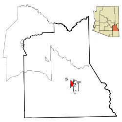
 Location in Graham County and the state of Arizona |
|
| Location in the United States | |
| Coordinates: 32°49′58″N 109°45′46″W / 32.83278°N 109.76278°WCoordinates: 32°49′58″N 109°45′46″W / 32.83278°N 109.76278°W | |
| Country | United States |
| State | Arizona |
| County | Graham |
| Government | |
| • Mayor | Bob Rivera |
| Area | |
| • Total | 6.7 sq mi (17.4 km2) |
| • Land | 6.7 sq mi (17.3 km2) |
| • Water | 0.02 sq mi (0.04 km2) |
| Elevation | 2,910 ft (887 m) |
| Population (2010) | |
| • Total | 4,865 |
| • Estimate (2014) | 5,023 |
| • Density | 726.1/sq mi (280.4/km2) |
| Time zone | MST (no DST) (UTC-7) |
| ZIP code | 85552 |
| Area code(s) | 928 |
| FIPS code | 04-73420 |
| Website | Town of Thatcher |
Thatcher is a town in Graham County, Arizona, United States. According to the 2010 Census, the population of the town is 4,865. It is part of the Safford Micropolitan Statistical Area.
Thatcher is the home of Eastern Arizona College (EAC), a college that offers two year degrees and includes a nursing school.
Thatcher is located at 32°49′58″N 109°45′46″W / 32.83278°N 109.76278°W (32.832685, -109.762879).
The town is centered in the Upper Gila River Valley with one of Arizona's famous Madrean Sky Islands towering to the south and the Gila River to the north.
According to the United States Census Bureau, the town has a total area of 6.7 square miles (17 km2), including 0.02 square miles (0.052 km2) of water.
As of the census of 2000, there were 4,022 people, 1,281 households, and 927 families residing in the town. The population density was 919.4 people per square mile (355.4/km²). There were 1,427 housing units at an average density of 326.2 per square mile (126.1/km²). The racial makeup of the town was 84.73% White, 0.77% Black or African American, 1.84% Native American, 0.52% Asian, 0.07% Pacific Islander, 9.87% from other races, and 2.19% from two or more races. 19.54% of the population were Hispanic or Latino of any race.
...
Wikipedia

