Ten Boer
| Ten Boer | |||
|---|---|---|---|
| Municipality | |||

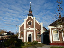
Church in Thesinge
|
|||
|
|||
 Location in Groningen |
|||
| Coordinates: 53°17′N 6°42′E / 53.283°N 6.700°ECoordinates: 53°17′N 6°42′E / 53.283°N 6.700°E | |||
| Country | Netherlands | ||
| Province | Groningen | ||
| Government | |||
| • Body | Municipal council | ||
| • Mayor | André van de Nadort (PvdA) | ||
| Area | |||
| • Total | 45.73 km2 (17.66 sq mi) | ||
| • Land | 45.30 km2 (17.49 sq mi) | ||
| • Water | 0.43 km2 (0.17 sq mi) | ||
| Elevation | 1 m (3 ft) | ||
| Population (February 2017) | |||
| • Total | 7,447 | ||
| • Density | 164/km2 (420/sq mi) | ||
| Time zone | CET (UTC+1) | ||
| • Summer (DST) | CEST (UTC+2) | ||
| Postcode | 9790–9799 | ||
| Area code | 050 | ||
| Website | www |
||
Ten Boer (Dutch pronunciation: [tɛn ˈbuːr]) is a municipality and a village in the northeastern Netherlands, in the province of Groningen. The municipality had a population of 7,447 in 2017; the village of Ten Boer has approximately 4,600 inhabitants.
Garmerwolde, Lellens, Sint Annen, Ten Boer, Ten Post, Thesinge, Winneweer, Wittewierum and Woltersum.
Dutch topographic map of the municipality of Ten Boer, June 2015
...
Wikipedia


