Teller County, Colorado
| Teller County, Colorado | ||
|---|---|---|

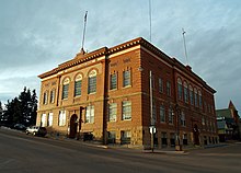
Teller County Court House in Cripple Creek
|
||
|
||
 Location in the U.S. state of Colorado |
||
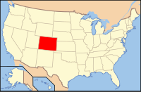
 Colorado's location in the U.S. |
||
| Founded | March 23, 1899 | |
| Seat | Cripple Creek | |
| Largest city | Woodland Park | |
| Area | ||
| • Total | 559 sq mi (1,448 km2) | |
| • Land | 557 sq mi (1,443 km2) | |
| • Water | 1.9 sq mi (5 km2), 0.3% | |
| Population (est.) | ||
| • (2015) | 23,385 | |
| • Density | 42/sq mi (16/km²) | |
| Congressional district | 5th | |
| Time zone | Mountain: UTC-7/-6 | |
| Website | www |
|
Teller County is one of the 64 counties in the U.S. state of Colorado. As of the 2010 census, the population was 23,350. The county seat is Cripple Creek, and the most populous city is Woodland Park.
Teller County is included in the Colorado Springs, CO Metropolitan Statistical Area.
A few years after gold was discovered in Cripple Creek, political differences between area miners and mine owners, many of whom lived in Colorado Springs, resulted in the division of El Paso County. Created in 1899, Teller County was carved from the western slope of Pikes Peak, and was named after United States Senator Henry M. Teller. Within five years of its formation, Teller County became the scene of a dramatic labor struggle called the Colorado Labor Wars.
According to the U.S. Census Bureau, the county has a total area of 559 square miles (1,450 km2), of which 557 square miles (1,440 km2) is land and 1.9 square miles (4.9 km2) (0.3%) is water.
As of the census of 2000, there were 20,555 people, 7,993 households, and 5,922 families residing in the county. The population density was 37 people per square mile (14/km²). There were 10,362 housing units at an average density of 19 per square mile (7/km²). The racial makeup of the county was 94.92% White, 0.55% Black or African American, 0.97% Native American, 0.58% Asian, 0.08% Pacific Islander, 0.90% from other races, and 2.00% from two or more races. 3.49% of the population were Hispanic or Latino of any race.
...
Wikipedia

