Tayshetsky District
| Tayshetsky District Тайшетский район (Russian) |
|
|---|---|
 Location of Tayshetsky District (#24) in western Irkutsk Oblast |
|
| Coordinates: 55°56′N 98°01′E / 55.933°N 98.017°ECoordinates: 55°56′N 98°01′E / 55.933°N 98.017°E | |
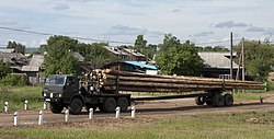
 Lumber transport in Yurty. Tayshetsky District |
|
| Location | |
| Country | Russia |
| Federal subject | Irkutsk Oblast |
| Administrative structure (as of July 2013) | |
| Administrative center | town of Tayshet |
| Inhabited localities: | |
| Cities/towns | 2 |
| Urban-type settlements | 4 |
| Rural localities | 82 |
| Municipal structure (as of October 2013) | |
| Municipally incorporated as | Tayshetsky Municipal District |
| Municipal divisions: | |
| Urban settlements | 6 |
| Rural settlements | 25 |
| Statistics | |
| Area | 27,800 km2 (10,700 sq mi) |
| Population (2010 Census) | 29,752 inhabitants |
| • Urban | 32.3% |
| • Rural | 67.7% |
| Density | 1.07/km2 (2.8/sq mi) |
| Time zone | IRKT (UTC+08:00) |
| Official website | |
| on | |
Tayshetsky District (Russian: Тайшетский райо́н) is an administrative district, one of the thirty-three in Irkutsk Oblast, Russia.Municipally, it is incorporated as Tayshetsky Municipal District. It is located in the west of the oblast. The area of the district is 27,800 square kilometers (10,700 sq mi). Its administrative center is the town of Tayshet. Population: 29,752 (2010 Census); 36,502 (2002 Census);35,236 (1989 Census).
Within the framework of administrative divisions, Tayshetsky District is one of the thirty-three in the oblast. The town of Tayshet serves as its administrative center. As a municipal division, the district is incorporated as Tayshetsky Municipal District.
...
Wikipedia
