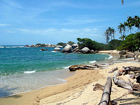
Tayrona National Natural Park
| Parque Natural Nacional Tayrona | |
|---|---|
|
IUCN category II (national park)
|
|
 |
|
| Location | Magdalena State, Colombia |
| Nearest city | Santa Marta |
| Coordinates | 11°16′N 74°3′W / 11.267°N 74.050°WCoordinates: 11°16′N 74°3′W / 11.267°N 74.050°W |
| Area | 150 km2 (58 sq mi) |
| Established | 1969 |
| Governing body | SINAP |
The Tayrona National Natural Park (Spanish: Parque Nacional Natural Tayrona) is a protected area in the Colombian northern Caribbean region and within the jurisdiction of the Department of Magdalena and 34 kilometres (21 mi) from the city of Santa Marta. The park presents a biodiversity endemic to the area of the Sierra Nevada de Santa Marta mountain range presenting a variety of climates (mountain climate) and geography that ranges from arid sea level to 900 meters above sea level. The park covers approximately 30 square kilometres (12 sq mi) of maritime area in the Caribbean sea and approximately 150 square kilometres (58 sq mi) of land.
It was the second most visited national park in Colombia in 2012, with 293,502 visitors. The most visited park was the Rosario and San Bernardo Corals National Natural Park.
The Tayrona National Park was created by the 191st Law of the Colombian Institute for Agrarian Reform (INCORA), in order to guarantee the protection of the region and the preserving of the ecological environment.
The park has an area of 150 square kilometers. It is located in the jurisdiction of the Santa Marta municipality, in the Department of Magdalena, alonged the north coast of Colombia that borders on the Caribbean Sea.
Taganga is its most southern part; its western boundary goes toward the northeast following the coastline, including a kilometer of sea area, until the Piedras River. The boundary follows the left side of the river until the North Highway, and then toward the west, crossing the following places with clear demarcations on the terrain:
...
Wikipedia

