Caribbean sea
| Caribbean Sea | |
|---|---|
 |
|
| Type | Sea |
| Surface area | 2,754,000 km2 (1,063,000 sq mi) |
| Max. depth | 7,686 m (25,217 ft) |
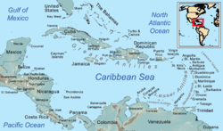
The Caribbean Sea (Spanish: Mar Caribe; French: Mer des Caraïbes Dutch: Caraïbische Zee) is a sea of the Atlantic Ocean in the tropics of the Western Hemisphere. It is bounded by Mexico and Central America to the west and south west, to the north by the Greater Antilles starting with Cuba, to the east by the Lesser Antilles, and to the south by the north coast of South America.
The entire area of the Caribbean Sea, the numerous islands of the West Indies, and adjacent coasts, are collectively known as the Caribbean. The Caribbean Sea is one of the largest seas and has an area of about 2,754,000 km2 (1,063,000 sq mi). The sea's deepest point is the Cayman Trough, between the Cayman Islands and Jamaica, at 7,686 m (25,220 ft) below sea level. The Caribbean coastline has many gulfs and bays: the Gulf of Gonâve, Gulf of Venezuela, Gulf of Darién, Golfo de los Mosquitos, Gulf of Paria and Gulf of Honduras.
The Caribbean Sea has the world's second biggest barrier reef, the Mesoamerican Barrier Reef. It runs 1,000 km (620 mi) along the coasts of Mexico, Belize, Guatemala, and Honduras.
The name "Caribbean" derives from the Caribs, one of the region's dominant Native American groups at the time of European contact during the late 15th century. After the discovery of America by Christopher Columbus in 1492, the Spanish term Antillas applied to the lands; stemming from this, "Sea of the Antilles" became a common alternative name for "Caribbean Sea" in various European languages. During the first century of development, Spanish dominance in the region remained undisputed.
...
Wikipedia
