Tarrytown, New York
| Tarrytown, New York | |
|---|---|
| Town | |

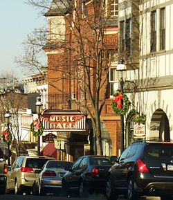
Main Street, showing the Music Hall
|
|
 Location of Tarrytown, New York |
|
| Coordinates: 41°4′9″N 73°51′35″W / 41.06917°N 73.85972°WCoordinates: 41°4′9″N 73°51′35″W / 41.06917°N 73.85972°W | |
| Country | United States |
| State | New York |
| County | Westchester |
| Incorporated | 1870 |
| Area | |
| • Total | 5.7 sq mi (14.7 km2) |
| • Land | 3.0 sq mi (7.7 km2) |
| • Water | 2.7 sq mi (7.0 km2) |
| Elevation | 121 ft (37 m) |
| Population (2010) | |
| • Total | 11,277 |
| • Density | 2,000/sq mi (770/km2) |
| Time zone | Eastern (EST) (UTC-5) |
| • Summer (DST) | EDT (UTC-4) |
| ZIP code | 10591 |
| Area code(s) | 914 |
| FIPS code | 36-73176 |
| GNIS feature ID | 0967065 |
| Website | www.tarrytowngov.com |
Tarrytown is a village in the town of Greenburgh in Westchester County, New York, United States. It is located on the eastern bank of the Hudson River, about 25 miles (40 km) north of midtown Manhattan in New York City, and is served by a stop on the Metro-North Hudson Line. To the north of Tarrytown is the village of Sleepy Hollow (formerly "North Tarrytown"), to the south the village of Irvington and to the east unincorporated parts of Greenburgh. The Tappan Zee Bridge crosses the Hudson at Tarrytown, carrying the New York State Thruway (Interstates 87 and 287) to South Nyack, Rockland County and points in Upstate New York. The population was 11,277 at the 2010 census.
The Native American Weckquaesgeek tribe, who were closely related to the Wappinger Confederacy and further related to the Mohicans, lived in the area prior to European settlement. They fished the Hudson River for shad, oysters and other shellfish. Their principal settlement was at what is now the foot of Church Street near the Hudson River shore, between the current location of Losee Park and the Tappan Zee Bridge, at a place they called Alipconk, or the "Place of Elms".
...
Wikipedia
