Taroom
|
Taroom Queensland |
|||||||||||||||
|---|---|---|---|---|---|---|---|---|---|---|---|---|---|---|---|

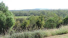
View towards the north-west from Gilbert's Lookout, 2014
|
|||||||||||||||
| Coordinates | 25°38′26″S 149°47′54″E / 25.64056°S 149.79833°ECoordinates: 25°38′26″S 149°47′54″E / 25.64056°S 149.79833°E | ||||||||||||||
| Population | 873 (2011 census) | ||||||||||||||
| Postcode(s) | 4420 | ||||||||||||||
| Location | |||||||||||||||
| LGA(s) | Shire of Banana | ||||||||||||||
| State electorate(s) | Callide | ||||||||||||||
| Federal Division(s) | Flynn | ||||||||||||||
|
|||||||||||||||
Taroom /təˈruːm/ is a town and locality in the Shire of Banana in Queensland, Australia. The town is located on the Dawson River and the Leichhardt Highway, 380 kilometres (240 mi) north west of the state capital, Brisbane, 261 kilometres (162 mi) from Rockhampton and 302 kilometres (188 mi) from Toowoomba. At the 2011 census, Taroom had a population of 873 people.
Prussian explorer Ludwig Leichhardt passed through the district in 1844, carving his initials and date on a coolibah tree that now stands in the centre of town. Leichhardt's carving is no longer visible following an alleged attempt to remove bark growing over the initials that removed the initials as well. Reporting the rich soils in the area, settlers began taking up land in 1845 and by 1850 a town had been established at a popular camping spot near the Dawson River.
Originally named Bonners Knob the town was renamed Taroom, possibly after the nearby Taroom cattle station, on completion of the first post office in 1856. The name Taroom is said to be an aboriginal Waka word tarum meaning wild lime.
Situated 40 kilometres (25 mi) west of Taroom is Hornet Bank Station which was the site of the 1857 Hornet Bank massacre, the genocidal reprisals for which led to the Yeeman Indigenous language group and people being wiped out.
...
Wikipedia

