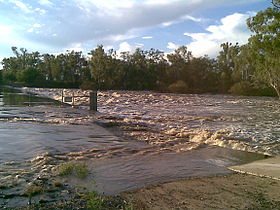
Dawson River (Queensland)
| Dawson | |
| River | |
|
Dawson River near Moura
|
|
| Name origin: In honour of Robert Dawson | |
| Country | Australia |
|---|---|
| State | Queensland |
| Region | Central Queensland |
| Part of | Fitzroy River |
| Tributaries | |
| - right | Don River (Central Queensland) |
| Towns | Baralaba, Theodore, Taroom |
| Source | Carnarvon Range |
| - location | northwest of Upper Dawson |
| - elevation | 642 m (2,106 ft) |
| - coordinates | 25°17′52″S 148°34′03″E / 25.29778°S 148.56750°E |
| Mouth | confluence with the Mackenzie River to form the Fitzroy River |
| - location | northeast of Duaringa |
| - elevation | 55 m (180 ft) |
| - coordinates | 24°57′50″S 150°04′23″E / 24.96389°S 150.07306°ECoordinates: 24°57′50″S 150°04′23″E / 24.96389°S 150.07306°E |
| Length | 735 km (457 mi) |
| Basin | 50,800 km2 (19,614 sq mi) |
| National parks | Carnarvon National Park; Expedition National Park; Precipice National Park |
|
Location of Dawson River mouth in Queensland
|
|
The Dawson River is a river located in Central Queensland, Australia.
The Dawson River rises in the Carnarvon Range, draining through the Carnarvon National Park, northwest of the settlement of Upper Dawson. The flows generally south by east, crossed by the Carnarvon Highway and then flows generally east through the settlement of Taroom where the river is crossed by the Leichhardt Highway. The river then flows in a northerly direction through the settlement of Theodore where the river is again crossed by the Leichhardt Highway. The river flows north through the settlement of Baralaba and towards Duaringa, crossed by the Capricorn Highway. A little further north, the Dawson River forms confluence with the Mackenzie River to form the Fitzroy River. From source to mouth, the river is joined by sixty-four tributaries, including the Don River, and descends 587 metres (1,926 ft) over its 735-kilometre (457 mi) course. Several weirs have been constructed along the river to provide water for cotton and dairy farming in the region. The river catchment covers an area of 50,800 square kilometres (19,600 sq mi).
Expedition National Park and the Precipice National Park are protected areas along the Dawson River.
...
Wikipedia


