Taroko National Park
| Taroko National Park | |
|---|---|
|
IUCN category II (national park)
|
|

Tunnel of Nine Turns
|
|
| Map of Taroko national park | |
| Location | Taiwan |
| Nearest city | Hualien City |
| Coordinates | 24°10′N 121°20′E / 24.167°N 121.333°ECoordinates: 24°10′N 121°20′E / 24.167°N 121.333°E |
| Area | 920 km2 (360 sq mi) |
| Established | 28 November 1986 |
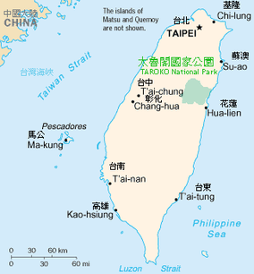
Taroko National Park (Chinese: 太魯閣國家公園; pinyin: Tàilǔgé gúojiā gōngyuán; Pe̍h-ōe-jī: Taroko kok-ka kong-hn̂g) is one of the nine national parks in Taiwan and was named after the Taroko Gorge, the landmark gorge of the park carved by the Liwu River. The park spans Taichung Municipality, Nantou County, and Hualien County.
The park was originally established as the Tsugitaka-Taroko National Park (Japanese: 次高タロコ国立公園 Hepburn: Tsugitaka Taroko kokuritsu kōen?) by the Governor-General of Taiwan on 12 December 1937 when Taiwan was part of the Empire of Japan. After the Empire of Japan's defeat in World War II, the Republic of China assumed control of Taiwan. The ROC government subsequently abolished the park on 15 August 1945. It was not until 28 November 1986 that the park was reestablished.
Sights include:
The name, Taroko(formally as Truku), means "human being" in the Truku language of the Truku indigenous tribe. Long ago a Truku tribesman saw the beauty of the azure Pacific when he walked out of the gorge. On seeing the magnificent scene, he cried "Taroko!". And so it became the name of the place, in a fashion not dissimilar to how the island, Formosa, got its name.
...
Wikipedia

