Tamsweg
| Tamsweg | ||
|---|---|---|

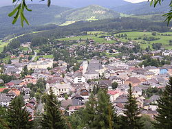
View from St Leonhard Church
|
||
|
||
| Location within Austria | ||
| Coordinates: 47°07′00″N 13°48′00″E / 47.11667°N 13.80000°ECoordinates: 47°07′00″N 13°48′00″E / 47.11667°N 13.80000°E | ||
| Country | Austria | |
| State | Salzburg | |
| District | Tamsweg | |
| Government | ||
| • Mayor | Georg Gappmayer (ÖVP) | |
| Area | ||
| • Total | 117.36 km2 (45.31 sq mi) | |
| Elevation | 1,022 m (3,353 ft) | |
| Population (1 January 2016) | ||
| • Total | 5,721 | |
| • Density | 49/km2 (130/sq mi) | |
| Time zone | CET (UTC+1) | |
| • Summer (DST) | CEST (UTC+2) | |
| Postal code | 5580 | |
| Area code | 06474 | |
| Vehicle registration | TA | |
| Website | www.tamsweg.at | |
Tamsweg is a market town in the Austrian state of Salzburg near the border with Styria. It is the administrative centre of the eponymous Tamsweg District (Bezirk) and the largest town of the Salzburg Lungau region.
Tamsweg is located on the southern slope of the Schladminger Tauern mountain range within the Central Eastern Alps, in the valley of the upper Mur River, the driest basin in Austria. The municipality consists of the cadastral communities of Haiden, Keusching, Lasaberg, Mörtelsdorf, Sauerfeld, Seetal, Tamsweg and Wölting.
Once part of the Roman Noricum province, the Lungau from the 6th century onwards was a Slavic settlement area, which in the 8th century fell under the influence of the Bavarian dukes. The locality of Taemswich was first mentioned about 1156. The parish church, originally a filial of nearby Mariapfarr, was acquired by Archbishop Eberhard II of Salzburg in 1246. The Prince-Archbishops had the Saint Leonard pilgrimage church erected about 1433, which in the late 15th century was enlarged as a fortified church in view of repeated Ottoman invasions. In 1490 it was occupied by Hungarian troops of King Matthias Corvinus and became the site of violent fights against the armed forces of Emperor Frederick III.
...
Wikipedia


