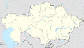
Talgar
|
Talgar Талғар |
|
|---|---|
| town | |
 |
|
| Location in Kazakhstan | |
| Coordinates: 43°18′N 77°14′E / 43.300°N 77.233°ECoordinates: 43°18′N 77°14′E / 43.300°N 77.233°E | |
| Country | Kazakhstan |
| Region | Almaty Region |
| First settled | IX |
| Founded | 1858 |
| Incorporated (city) | 1959 |
| Government | |
| • Akim (mayor) | T.A. Umraliev |
| Area | |
| • Total | 18.8 km2 (7.3 sq mi) |
| Elevation | 1,000 - 1,500 m (−3,900 ft) |
| Population (2009) | |
| • Total | 49,865 |
| Time zone | UTC (UTC+6) |
| Postal code | 041601-041605 (town) |
| Area code(s) | +7 72774 |
| Website | http://www.akimat-talgar.gov.kz |
Talgar (Kazakh: Талғар [tɑlˈɣɑr] ; Russian: Талгар) is a town in Almaty Region, southeastern Kazakhstan. It is the administrative center of Talgar District. The town is located between Almaty and Esik, 25 km from Almaty and several kilometres east of Birlik. Population: 45,529 (2009 Census results); 43,353 (1999 Census results).
There are several possible explanations for the town's name. The most obvious is that Talgar originates from a later modified name of an ancient settlement of Talkhiz, situated in the Talgar suburbs.
The first records of Talgar settlement were made by a Persian geographer in a medieval geographical treatise Hudud al-'Alam ("Borders of The World") in 982. The settlement bore a name Talkhiz and was situated in the mountains of Semirechye at the borders of Turkic tribes Karluk and Chigils. The geographer described inhabitants of Talkhiz as "brave, martial, and valiant people". Scientists analyzed the name of the settlement and concluded it to have been distorted by a copyist, so that originally it sounded as “Talkhir”. However, Talkhir (Talgar) is a well-known name in modern Kazakhstan. A town neighboring to Almaty, its river and the highest peak of Zailiisky Alatau also bear this name. It became obvious that the ancient settlement had been situated somewhere close by. Thus, archeological excavations in the southeastern suburbs of modern Talgar revealed the mysterious settlement.
...
Wikipedia

