Esik
|
Esik Eсik |
||
|---|---|---|
|
||
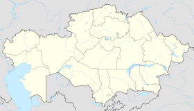
| Location in Kazakhstan | ||
| Coordinates: 43°21′N 77°28′E / 43.350°N 77.467°ECoordinates: 43°21′N 77°28′E / 43.350°N 77.467°E | ||
| Country | Kazakhstan | |
| Region | Almaty Region | |
| First settled | XIX | |
| Founded | 1858 | |
| Incorporated (city) | 1968 | |
| Area | ||
| • Total | 25.8 km2 (10.0 sq mi) | |
| Elevation | 1,214 m (3,983 ft) | |
| Population (2009) | ||
| • Total | 34,355 | |
| Time zone | UTC (UTC+6) | |
| Postal code | 040400 (town) | |
| Area code(s) | +7 72775 | |
| License plate | 05, B | |
Esik (Kazakh: Есік, also spelled Issyk, Yesik and Yesyk) is a town in Almaty Region of Kazakhstan, the administrative center of Enbekshikazakh District. It is located on the Issyk River, at the foot of the Tian Shan, 53 km east of Almaty and 112 km over the mountains from Issyk Kul Lake. Population: 34,355 (2009 Census results); 31,254 (1999 Census results).
It was founded by Cossacks in 1858 as stanitsa Nadezhdinskaya. The Issyk kurgan of the famous "Golden Man" is nearby.
The nearby Issyk Lake (not to be confused with the much greater Issyk Kul Lake in Kyrgyzstan) is mostly famous for the way it was created (as a result of an ancient natural landslide damming a valley), destroyed (another natural landslide destroying that dam in 1963, with a subsequent damage to the city of Esik as well), and re-created (with human help).
Esik served as the host community for the 20th group of US Peace Corps OCAP (Organization and Community Assistance Program) volunteers in Kazakhstan during their initial training. 20 families hosted the volunteers for 3 months, beginning with their arrival in the country in August 2008.
...
Wikipedia


