Takhar Province
|
Takhar Persian: تخار Pashto: تخار ولايت |
|
|---|---|
| Province | |

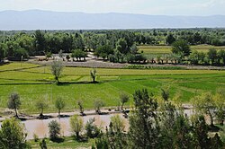
View from atop a hill in Khawajah Bahawuddin, Takhar Province, Afghanistan.
|
|
 Map of Afghanistan with Takhar highlighted |
|
| Coordinates (Capital): 36°42′N 69°48′E / 36.7°N 69.8°ECoordinates: 36°42′N 69°48′E / 36.7°N 69.8°E | |
| Country | Afghanistan |
| Capital | Taloqan |
| Government | |
| • Governor | Yasin Zia |
| Area | |
| • Total | 12,333 km2 (4,762 sq mi) |
| Population (2012) | |
| • Total | 933,700 |
| • Density | 76/km2 (200/sq mi) |
| Time zone | UTC+4:30 |
| Main languages | Dari (Afghan Persian) |
Takhar (Persian: تخار; Pashto: تخار ولايت) is one of the thirty-four provinces of Afghanistan, located in the northeast of the country next to Tajikistan. It is surrounded by Badakhshan in the east, Panjshir in the south, and Baghlan and Kunduz in the west. The city of Taloqan serves as its capital.
The province contains about 17 districts, over 1,000 villages, and approximately 933,700 people, which is multi-ethnic and mostly a rural society. The major ethnic groups in the province are Tajiks and Uzbeks followed by Pashtuns, Hazara, and others.
Between the early 16th century and the mid-18th century, the territory was ruled by the Khanate of Bukhara. It was given to Ahmad Shah Durrani by Murad Beg of Bukhara after a treaty of friendship was reached in or about 1750, and became part of the Durrani Empire. It was ruled by the Durranis followed by the Barakzai dynasty, and was untouched by the British during the three Anglo-Afghan wars that were fought in the 19th and 20th centuries. It remained peaceful for about one hundred years until the 1980s Soviet war in Afghanistan.
...
Wikipedia
