Taghit
|
Taghit ﺗﺎﻏﻴﺖ |
|
|---|---|
| Commune and town | |
 |
|
 Location of Taghit commune within Béchar Province |
|
| Location of Taghit within Algeria | |
| Coordinates: 30°55′N 2°2′W / 30.917°N 2.033°WCoordinates: 30°55′N 2°2′W / 30.917°N 2.033°W | |
| Country |
|
| Province | Béchar Province |
| District | Taghit District (coextensive) |
| Area | |
| • Total | 8,080 km2 (3,120 sq mi) |
| Elevation | 623 m (2,044 ft) |
| Population (2008) | |
| • Total | 6,317 |
| • Density | 0.78/km2 (2.0/sq mi) |
| Time zone | CET (UTC+1) |
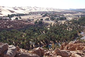
Taghit (Arabic: ﺗﺎﻏﻴﺖ) is a town and commune in Taghit District, Béchar Province, in western Algeria. The town is an oasis watered by the underground Oued Zousfana, which runs along beside the dunes of the Grand Erg Occidental. According to the 2008 census its population is 6,317, up from 6,047 in 1998, with an annual growth rate of 0.4%. The commune covers an area of 8,080 square kilometres (3,120 sq mi).
The town was the site of the Battle of Taghit in 1903, in which 4000 Zayanes Berbers besieged the French in the town, whom they outnumbered by 10 to 1. The attackers were later forced to retreat.
Taghit lies on the left (eastern) bank of the Oued Zouzfana. The Grand Erg Occidental, a large area of continuous sand dunes, lies to the east, while the rocky Djebel Baroun lies to the west across the river.
Taghit has a hot desert climate (Köppen climate classification BWh), with extremely hot summers and cool winters, and very little precipitation throughout the year.
Agriculture is an important industry in Taghit. The commune has a total of 2,280 hectares (5,600 acres) of arable land, of which 1,432 hectares (3,540 acres) is irrigated. There are a total of 137,450 date palms planted in the commune. As of 2009 there were 3,330 sheep, 2,995 goats, 2,481 camels, and 62 cattle. There were also 24,000 chickens in 2 buildings.
...
Wikipedia

