Tadcaster
| Tadcaster | |
|---|---|
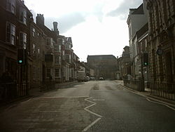
 High Street, Tadcaster |
|
| Tadcaster shown within North Yorkshire | |
| Population | 6,003 (2011 census) |
| OS grid reference | SE4843 |
| • London | 170 mi (270 km) SSE |
| District | |
| Shire county | |
| Region | |
| Country | England |
| Sovereign state | United Kingdom |
| Post town | TADCASTER |
| Postcode district | LS24 |
| Dialling code | 01937 |
| Police | North Yorkshire |
| Fire | North Yorkshire |
| Ambulance | Yorkshire |
| EU Parliament | Yorkshire and the Humber |
| UK Parliament | |
Tadcaster is a market town and civil parish in the Selby district of North Yorkshire, England. It is approximately 3 miles (5 km) east of the Great North Road, 12 miles (19 km) north-east of Leeds, and 10 miles (16 km) south-west of York.
It is the last town the River Wharfe passes before it joins the River Ouse about 10 miles (16 km) downstream. It is in the shire county of North Yorkshire, although historically split between the Ainsty of York and the West Riding of Yorkshire.
The town is twinned with Saint-Chély-d'Apcher in France.
The Romans built a settlement and named it Calcaria from the Latin word for lime, reflecting the importance of the area's limestone geology as a natural resource for quarrying, an industry which continues and has contributed to many notable buildings including York Minster. Calcaria was an important staging post that grew at the crossing of the River Wharfe on the road to Eboracum (York).
The suffix of the Anglo-Saxon name Tadcaster is derived from the borrowed Latin word castra meaning 'fort', although the Angles and Saxons used the term for any walled Roman settlement. Tadcaster is first mentioned in the Anglo-Saxon Chronicle, where it appears as Táda, referring to the place where King Harold assembled his army and fleet before entering York and proceeding onwards to the Battle of Stamford Bridge in 1066.
...
Wikipedia

