Szydłów
| Szydłów | |
|---|---|
| Village | |

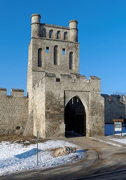
The Kraków Gate in Szydłów
|
|
| Coordinates: 50°35′28″N 21°00′13″E / 50.59111°N 21.00361°E | |
| Country |
|
| Voivodeship | Świętokrzyskie |
| County | Staszów |
| Gmina | Szydłów |
| Sołectwo | Szydłów |
| Elevation | 250.6 m (822.2 ft) |
| Population (31 December 2009 at Census) | |
| • Total |
|
| Time zone | CET (UTC+1) |
| • Summer (DST) | CEST (UTC+2) |
| Postal code | 28-225 |
| Area code(s) | +48 41 |
| Car plates | TSZ |
| Website | www.szydlow.pl |
Szydłów[ˈʂɨdwuf] is a village in Staszów County, Świętokrzyskie Voivodeship, Lesser Poland. It is the seat of the gmina (administrative district) called Gmina Szydłów. It lies approximately 13 kilometres (8 mi) west of Staszów and 43 km (27 mi) south-east of the regional capital Kielce. The village has a population of ![]() 1,093.
1,093.
Szydłów's history dates to the 12th century. It gained its city rights in 1329 and lost them in 1869. The village several tourist attractions, including the 16th-century Szydłów Synagogue, several buildings and churches dating to the 14th century and the ruins of a castle from the same period. The first official inventory of important buildings in Poland, A General View of the Nature of Ancient Monuments in the Kingdom of Poland, led by Kazimierz Stronczyński from 1844–55, describes the Szydłów Synagogue as one of Poland's architecturally notable buildings.
Szydłów is located in Lesser Polish Upland, between the Świętokrzyskie Mountains and the Połaniec Plain. The village lies within borders of Chmielnik–Szydłów Protected Landscape Area. The distance to Kielce is 40 kilometers, to Staszów 12 kilometers. Due to numerous plum orchards, the village is called Plum Capital of Poland. Every year, the Plum Festival takes place here. The village is crossed by two regional roads—765th and 756th; furthermore, Szydłów is a stop along Lesser Polish Way.
...
Wikipedia

