Syzransky District
| Syzransky District Сызранский район (Russian) |
|
|---|---|
 Location of Syzransky District in Samara Oblast |
|
| Coordinates: 53°10′N 48°28′E / 53.167°N 48.467°ECoordinates: 53°10′N 48°28′E / 53.167°N 48.467°E | |
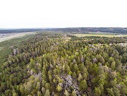
 Racheyskie Rocks, Syzransky District |
|
| Location | |
| Country | Russia |
| Federal subject | Samara Oblast |
| Administrative structure (as of 2011) | |
| Administrative center | city of Syzran |
| Inhabited localities: | |
| Urban-type settlements | 2 |
| Rural localities | 67 |
| Municipal structure (as of October 2010) | |
| Municipally incorporated as | Syzransky Municipal District |
| Municipal divisions: | |
| Urban settlements | 2 |
| Rural settlements | 13 |
| Statistics | |
| Area | 1,887 km2 (729 sq mi) |
| Population (2010 Census) | 25,947 inhabitants |
| • Urban | 22.9% |
| • Rural | 77.1% |
| Density | 13.75/km2 (35.6/sq mi) |
| Time zone | SAMT (UTC+04:00) |
| Official website | |
| on | |
Syzransky District (Russian: Сы́зранский райо́н) is an administrative and municipal district (raion), one of the twenty-seven in Samara Oblast, Russia. It is located in the west of the oblast. The area of the district is 1,887 square kilometers (729 sq mi). Its administrative center is the city of Syzran (which is not administratively a part of the district). Population: 25,947 (2010 Census);23,964 (2002 Census);25,250 (1989 Census).
Within the framework of administrative divisions, Syzransky District is one of the twenty-seven in the oblast. The city of Syzran serves as its administrative center, despite being incorporated separately as a city of oblast significance—an administrative unit with the status equal to that of the districts.
As a municipal division, the district is incorporated as Syzransky Municipal District. The city of oblast significance of Syzran is incorporated separately from the district as Syzran Urban Okrug.
...
Wikipedia
