Symi
|
Symi Σύμη |
|
|---|---|
 |
|
| Coordinates: 36°35′N 27°50′E / 36.583°N 27.833°ECoordinates: 36°35′N 27°50′E / 36.583°N 27.833°E | |
| Country | Greece |
| Administrative region | South Aegean |
| Regional unit | Rhodes |
| Government | |
| • Mayor | Eleftherios Papakalodoukas |
| Area | |
| • Municipality | 65.754 km2 (25.388 sq mi) |
| Highest elevation | 617 m (2,024 ft) |
| Lowest elevation | 0 m (0 ft) |
| Population (2011) | |
| • Municipality | 2,590 |
| • Municipality density | 39/km2 (100/sq mi) |
| Time zone | EET (UTC+2) |
| • Summer (DST) | EEST (UTC+3) |
| Postal code | 856 00 |
| Area code(s) | 224x0 |
| Vehicle registration | ΚΧ, ΡΟ, ΡΚ |
| Website | symi.gr |
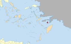
Symi, also transliterated as Syme or Simi (Greek: Σύμη), is a Greek island and municipality. It is mountainous and includes the harbor town of Symi and its adjacent upper town Ano Symi, as well as several smaller localities, beaches, and areas of significance in history and mythology. Symi is part of the Rhodes regional unit.
The economy of Symi was traditionally based on the shipbuilding and sponge industries. The population reached 22,500 at its peak during that period. Symi's main industry is now tourism, and its permanent population has declined to 2,500, with a larger population during the summer.
Geographically, Symi is part of the Dodecanese island chain, located about 41 kilometres (25 miles) north-northwest of Rhodes (and 425 km (264 mi) from Piraeus, the port of Athens), with 58.1 square kilometres (22.4 sq mi) of mountainous terrain. Its nearest land neighbors are the Datça and Bozburun peninsulas of Muğla Province in Turkey. Its interior is dotted with small valleys, and its coastline alternates between rocky cliffs and beaches, and isolated coves. Its main town, located on the northeast coast, is also named Symi and consists of the lower town around the harbour, typically referred to as Yialos, and the upper town is called Horio or Ano Symi. Other inhabited localities are Pedi, Nimborio, Marathounda and Panormitis. Panormitis is the location of the island's famous monastery which is visited by people from all over the world, and many Greeks pay homage to St Michael of Panormitis each year. The island has 2,580 inhabitants, mostly engaged in tourism, fishing, and trade. In the tourist season which lasts from Easter until Panormitis Day in early November, tourists and day-trippers increase the number of people on the island to as much as 6000. In addition to its many historical sites, the island's isolated beaches, many reachable only with small boats, are popular with tourists. The Municipality of Sými includes the uninhabited offshore islets of Gialesíno, Diavátes, Kouloúndros, Marmarás, Nímos, Sesklío, and Chondrós. Its total land area is 65.754 square kilometres (25.388 sq mi).
...
Wikipedia


