Swayzee, Indiana
| Swayzee, Indiana | |
|---|---|
| Town | |

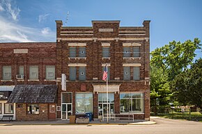
Swayzee Town Hall
|
|
 Location of Swayzee in the state of Indiana |
|
| Coordinates: 40°30′25″N 85°49′31″W / 40.50694°N 85.82528°WCoordinates: 40°30′25″N 85°49′31″W / 40.50694°N 85.82528°W | |
| Country | United States |
| State | Indiana |
| County | Grant |
| Township | Sims |
| Area | |
| • Total | 0.47 sq mi (1.22 km2) |
| • Land | 0.47 sq mi (1.22 km2) |
| • Water | 0 sq mi (0 km2) |
| Elevation | 860 ft (262 m) |
| Population (2010) | |
| • Total | 981 |
| • Estimate (2012) | 976 |
| • Density | 2,087.2/sq mi (805.9/km2) |
| Time zone | Eastern (EST) (UTC-5) |
| • Summer (DST) | EDT (UTC-4) |
| ZIP code | 46986 |
| Area code(s) | 765 |
| FIPS code | 18-74510 |
| GNIS feature ID | 0444475 |
| Website | http://www.swayzee.org |
Swayzee is a town in Sims Township, Grant County, Indiana, United States. The population was 981 at the 2010 census.
On its welcome sign, Swayzee claims to be "the only Swayzee in the world." This motto is based on a story about a postcard sent by a serviceman overseas during World War II, which although being addressed only to "Swayzee", with no mention of Indiana or any other information, was still said to have been successfully delivered.
James Swayzee was the original owner of the town site.
Pipe Creek Sinkhole, uncovered in 1996 at the Pipe Creek Junior limestone quarry near Swayzee, has been the site of important paleontological discoveries dating from the Pliocene epoch.
Swayzee is located at 40°30′25″N 85°49′31″W / 40.50694°N 85.82528°W (40.506875, -85.825252) approximately eight miles west of the city of Marion. State Road 13 passes north and south through town along Washington Street, and State Road 22/Route 35 runs east and west about two & half mile south of town.
According to the 2010 census, Swayzee has a total area of 0.47 square miles (1.22 km2), all land.
Swayzee is home to churches of three Christian denominations: United Methodist, Nazarene, and United Church of Christ.
...
Wikipedia
