Sunset Park, Brooklyn
| Sunset Park, Brooklyn | |
|---|---|
| Neighborhood of Brooklyn | |

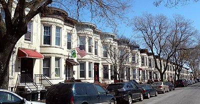
A residential block of rowhouses in Sunset Park
|
|
| Country |
|
| State |
|
| City | New York City |
| Borough | Brooklyn |
| Government | |
| • Council Member | Carlos Menchaca |
| Population (2010) | |
| • Total | 126,000 |
| ZIP code | 11220, 11232, 11215 |
| Area code(s) | 347, 646, 718, 917, 929 |
|
Sunset Park Historic District
|
|
| Location | Roughly bounded by Fourth Ave., Thirty-eighth St., Seventh Ave. and Sixty-fourth St., Brooklyn, New York |
| Area | 280 acres (110 ha) |
| Architectural style | Renaissance Revival, Romanesque Revival, Neo-Grec; Classical Revival |
| NRHP Reference # | 88001464 |
| Added to NRHP | September 15, 1988 |
Coordinates: 40°38′44″N 74°0′43″W / 40.64556°N 74.01194°W
Sunset Park is a neighborhood in the western part of the New York City borough of Brooklyn. It is bounded by the Gowanus Expressway/17th Street, Park Slope, Greenwood Heights and Green-Wood Cemetery to the north, 8th Avenue and Borough Park to the east, 65th Street and Bay Ridge to the south, and Upper New York Bay to the west. Because it was once close to the southern boundary of the City of Brooklyn, Sunset Park is considered to be part of South Brooklyn. However, until the 1960s, the northern part of Sunset Park was considered to be part of Gowanus, and the southern part was included in Bay Ridge. The neighborhood received its own name in that decade.
The 24.5-acre (9.9 ha) public Sunset Park, for which the neighborhood was named, was founded in the 1890s, and is located between 41st and 44th Streets and 5th and 7th Avenues. The park's elevated location offers views of New York Harbor; Manhattan; the Statue of Liberty; and, more distantly, the hills of Staten Island and New Jersey.
...
Wikipedia


