Sumter County, Alabama
| Sumter County, Alabama | |
|---|---|

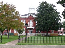
Sumter County Courthouse in Livingston
|
|
 Location in the U.S. state of Alabama |
|
 Alabama's location in the U.S. |
|
| Founded | December 18, 1832 |
| Named for | Thomas Sumter |
| Seat | Livingston |
| Largest city | Livingston |
| Area | |
| • Total | 913 sq mi (2,365 km2) |
| • Land | 904 sq mi (2,341 km2) |
| • Water | 9.4 sq mi (24 km2), 1.0% |
| Population (est.) | |
| • (2015) | 13,103 |
| • Density | 15/sq mi (6/km²) |
| Congressional district | 7th |
| Time zone | Central: UTC-6/-5 |
| Website | sumtercountyal |
|
Footnotes:
|
|
Footnotes:
Sumter County is a county of the U.S. state of Alabama. As of the 2010 census, the population was 13,763. Its county seat is Livingston. Its name is in honor of General Thomas Sumter of South Carolina.
Sumter County was established on December 18, 1832. From 1797 to 1832, Sumter County was part of the Choctaw Nation, which was made up of four main villages. The first settlers in Sumter County were French explorers who had come north from Mobile. They built and settled at Fort Tombecbee, near the modern-day town of Epes. In 1830, with the Treaty of Dancing Rabbit Creek, the Choctaw Indians ceded the land that is now Sumter County to the government.
According to the U.S. Census Bureau, the county has a total area of 913 square miles (2,360 km2), of which 904 square miles (2,340 km2) is land and 9.4 square miles (24 km2) (1.0%) is water. It is intersected by the Noxubee River.
As of the 2010 United States Census, there were 13,763 people residing in the county. 75.0% were Black or African American, 24.2% White, 0.2% Asian, 0.1% Native American, 0.2% of some other race and 0.3% of two or more races. 0.6% were Hispanic or Latino (of any race).
...
Wikipedia
