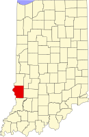
Sullivan County, Indiana
| Sullivan County, Indiana | |
|---|---|

Sullivan County Courthouse
|
|
 Location in the U.S. state of Indiana |
|
 Indiana's location in the U.S. |
|
| Founded | January 15, 1817 |
| Seat | Sullivan |
| Largest city | Sullivan |
| Area | |
| • Total | 454.12 sq mi (1,176 km2) |
| • Land | 447.14 sq mi (1,158 km2) |
| • Water | 6.97 sq mi (18 km2), 1.53% |
| Population | |
| • (2010) | 21,475 |
| • Density | 49/sq mi (19/km²) |
| Congressional district | 8th |
| Time zone | Eastern: UTC-5/-4 |
| Footnotes: Indiana county number 77 | |
| Sullivan, Indiana | ||||||||||||||||||||||||||||||||||||||||||||||||||||||||||||
|---|---|---|---|---|---|---|---|---|---|---|---|---|---|---|---|---|---|---|---|---|---|---|---|---|---|---|---|---|---|---|---|---|---|---|---|---|---|---|---|---|---|---|---|---|---|---|---|---|---|---|---|---|---|---|---|---|---|---|---|---|
| Climate chart () | ||||||||||||||||||||||||||||||||||||||||||||||||||||||||||||
|
||||||||||||||||||||||||||||||||||||||||||||||||||||||||||||
|
||||||||||||||||||||||||||||||||||||||||||||||||||||||||||||
| J | F | M | A | M | J | J | A | S | O | N | D |
|
2.8
36
18
|
2.6
42
22
|
3.2
52
31
|
4.2
64
42
|
4.1
73
52
|
3.5
82
61
|
4.7
85
65
|
3.8
84
63
|
3.7
78
56
|
3
67
44
|
4.1
53
34
|
3
40
23
|
| Average max. and min. temperatures in °F | |||||||||||
| Precipitation totals in inches | |||||||||||
| Source: The Weather Channel | |||||||||||
| Metric conversion | |||||||||||
|---|---|---|---|---|---|---|---|---|---|---|---|
| J | F | M | A | M | J | J | A | S | O | N | D |
|
71
2
−8
|
66
6
−6
|
82
11
−1
|
107
18
6
|
104
23
11
|
90
28
16
|
119
29
18
|
97
29
17
|
94
26
13
|
77
19
7
|
104
12
1
|
77
Wikipedia
...
|
