Sullivan, New York
| Sullivan, New York | |
|---|---|
| Town | |

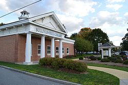
Sullivan Free Library
|
|
| Location within the state of New York | |
| Coordinates: 43°4′N 75°52′W / 43.067°N 75.867°W | |
| Country | United States |
| State | New York |
| County | Madison |
| Government | |
| • Type | Town Council |
| • Town Supervisor | John M. Becker (R) |
| • Town Council |
Members' List
|
| Area | |
| • Total | 73.6 sq mi (191 km2) |
| • Land | 73.4 sq mi (190 km2) |
| • Water | 0.2 sq mi (0.5 km2) |
| Elevation | 410 ft (120 m) |
| Population (2010) | |
| • Total | 15,339 |
| Time zone | Eastern (EST) (UTC-5) |
| • Summer (DST) | EDT (UTC-4) |
| ZIP code | 13030, 13037 |
| Area code(s) | 315 |
| FIPS code | 36-71993 |
| GNIS feature ID | 0979535 |
| Website | Town of Sullivan government site |
Coordinates: 43°4′N 75°52′W / 43.067°N 75.867°W
Sullivan is a town in Madison County, New York, United States. The population was 15,339 at the 2010 census. The town is named after General John Sullivan.
The Town of Sullivan is located in the northwest corner of the county.
Settlement began around 1790. The town was established in 1803 from the Town of Cazenovia. In 1809, the town was partitioned to form the Town of Lenox.
The Chittenango Landing Dry Dock Complex was listed on the National Register of Historic Places in 1992.
According to the United States Census Bureau, the town has a total area of 73.6 square miles (190.5 km²), of which, 73.4 square miles (190.0 km²) is land and 0.2 square miles (0.5 km²) (0.27%) is water.
The northern border of the town is Oneida Lake, and the west border is the Chittenango Creek.
The New York State Thruway (Interstate 90) passes across the town.
...
Wikipedia

