Sugar Creek, Missouri
| Sugar Creek, Missouri | |
|---|---|
| City | |
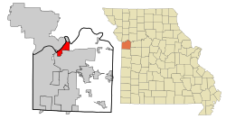
 Location of Sugar Creek, Missouri |
|
| Coordinates: 39°7′5″N 94°26′8″W / 39.11806°N 94.43556°WCoordinates: 39°7′5″N 94°26′8″W / 39.11806°N 94.43556°W | |
| Country | United States |
| State | Missouri |
| Counties | Jackson, Clay |
| Area | |
| • Total | 11.33 sq mi (29.34 km2) |
| • Land | 10.54 sq mi (27.30 km2) |
| • Water | 0.79 sq mi (2.05 km2) |
| Elevation | 820 ft (250 m) |
| Population (2010) | |
| • Total | 3,345 |
| • Estimate (2012) | 3,341 |
| • Density | 317.4/sq mi (122.5/km2) |
| Time zone | Central (CST) (UTC-6) |
| • Summer (DST) | CDT (UTC-5) |
| ZIP code | 64054 |
| Area code(s) | Area code 816 |
| FIPS code | 29-71368 |
| GNIS feature ID | 0727219 |
Sugar Creek is a city in Clay and Jackson counties in the U.S. state of Missouri. The population was 3,345 at the 2010 census.
Sugar Creek is located at 39°07′05″N 94°26′08″W / 39.118014°N 94.435630°W (39.118014, -94.435630).
According to the United States Census Bureau, the city has a total area of 11.33 square miles (29.34 km2), of which, 10.54 square miles (27.30 km2) is land and 0.79 square miles (2.05 km2) is water.
Like many cities along the Missouri River, Sugar Creek shows evidence of having once been the home of the Osage people. The city takes its name from nearby Sugar Creek.
On June 25, 1804, the Lewis and Clark Expedition camped on an island in the Missouri River opposite what is modern day Sugar Creek.
In the mid-1800s, the area now known as Sugar Creek served as an important link in America's westward expansion. Known as Upper Independence Landing originally, the territory along the Missouri River served as a port to receive supplies for early pioneers. It was renamed Wayne City Landing after an army lieutenant, Anthony Wayne. Wayne City, which is now on the national historic register, also received travelers who were headed west along the Oregon, California and Santa Fe Trails. In 1850, the first railroad west of the Mississippi River was constructed to join Wayne City and nearby Independence, Missouri.
...
Wikipedia
