Streetsville, Ontario
| Streetsville | |
|---|---|
| Neighbourhood | |

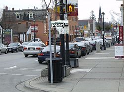
Streetsville is marked by street signs and banners along Queen Street.
|
|
| Nickname(s): The Village in the City | |
| Coordinates: 43°35′12″N 79°43′17″W / 43.58667°N 79.72139°W | |
| Country | Canada |
| Province | Ontario |
| Regional municipality | Peel |
| City | Mississauga |
| Settled | 1819 |
| Population (2009) | |
| • Total | 47,327 |
| Time zone | Eastern (UTC-5) |
| Forward sortation area | L5M |
| Area code(s) | 905 and 289 |
| NTS Map | 030M12 |
| GNBC Code | FCTEI |
Streetsville (pop. 47,327) is a neighbourhood located in the northwestern corner of the city of Mississauga, Ontario, Canada, on the Credit River. Although Streetsville occupies the west and east banks of the river, the majority is located on the west bank of the river.
A town prior to the 1974 amalgamations that formed the City of Mississauga, it seeks to keep a "small town" charm by retaining a variety of historical buildings and streetscapes. As part of this attempt to maintain a separate identity from the larger city, the names of several main Mississauga roads, as they pass through Streetsville, remain as they were when Streetsville was an independent village. These include Mississauga Road and Bristol Road, which remain as Queen Street and Main Street respectively. Other main thoroughfares that cross Streetsville include Creditview Road, Eglinton Avenue, and Britannia Road.
The area surrounding the Credit River was populated by the Iroquois people up until the early 18th century, when it was taken by the Ojibwa. European settlers came to know them specifically as the Mississaugas, which eventually became the name of the area itself. By 1805, the Natives had either ceded or sold most of this land over to British governance.
The beginnings of Streetsville are interwoven with the history of its founder, Timothy Street. Street was born in 1778 in the American colonies to a British Loyalist family. At the age of 23, he moved with his family from New York to St. David's, a settlement on the Niagara River in Upper Canada (now known as Ontario).
In 1818, the British made a second purchase of 648,000 acres (2,620 km2) of land from the indigenous Mississauga peoples. Before it could be opened for settlement, the land had to be surveyed, and as was usual for the time, surveyors would receive a grant of land from the parcel that they surveyed as compensation for their work. Timothy Street, along with Richard Bristol, a qualified surveyor, applied for a contract to survey parts of the newly available land. As they did their work, Street quickly began to appreciate the immense potential for settlement along the Credit River, and made plans to erect both a saw and grist mill once his work was finished.
...
Wikipedia
