Streetman, Texas
| Streetman, Texas | |
|---|---|
| Town | |
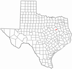
 Location of Streetman, Texas |
|
 |
|
| Coordinates: 31°52′37″N 96°19′28″W / 31.87694°N 96.32444°WCoordinates: 31°52′37″N 96°19′28″W / 31.87694°N 96.32444°W | |
| Country | United States |
| State | Texas |
| Counties | Freestone, Navarro |
| Area | |
| • Total | 0.48 sq mi (1.25 km2) |
| • Land | 0.48 sq mi (1.24 km2) |
| • Water | 0.004 sq mi (0.01 km2) |
| Elevation | 371 ft (113 m) |
| Population (2010) | |
| • Total | 247 |
| • Density | 515/sq mi (198.8/km2) |
| Time zone | Central (CST) (UTC-6) |
| • Summer (DST) | CDT (UTC-5) |
| ZIP code | 75859 |
| Area code(s) | 903 |
| FIPS code | 48-70604 |
| GNIS feature ID | 1347998 |
Streetman is a town in Freestone and Navarro counties in the U.S. state of Texas. As of the 2010 census the population was 247, up from 203 at the 2000 census.
Streetman is located in northern Freestone County at 31°52′37″N 96°19′28″W / 31.87694°N 96.32444°W (31.876973, -96.324452). A largely undeveloped part of the town extends north into Navarro County.
Streetman is on Texas State Highway 75, which leads southeast 14 miles (23 km) to Fairfield, the Freestone County seat. Interstate 45 passes southwest of Streetman, with access from Exits 211 and 213. I-45 leads north 74 miles (119 km) to Dallas and south 165 miles (266 km) to Houston.
According to the United States Census Bureau, the town has a total area of 0.48 square miles (1.25 km2), of which 0.0039 square miles (0.01 km2), or 0.60%, is water.
As of the census of 2000, there were 203 people, 102 households, and 55 families residing in the town. The population density was 421.6 people per square mile (163.3/km²). There were 128 housing units at an average density of 265.8 per square mile (103.0/km²). The racial makeup of the town was 83.74% White, 14.78% African American, 0.99% from other races, and 0.49% from two or more races. Hispanic or Latino of any race were 4.43% of the population.
...
Wikipedia
