Stirling, Alberta
| Stirling | |||
|---|---|---|---|
| Village | |||
| Village of Stirling | |||

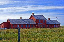
Galt Historic Railway Park north of Stirling.
|
|||
|
|||
| Nickname(s): The Junction Town (1912) Village of Gardens A Town of Two Towns |
|||
| Motto: Experience The History | |||
| Location of Stirling in Alberta | |||
| Coordinates: 49°30′08″N 112°31′00″W / 49.50222°N 112.51667°W | |||
| Country |
|
||
| Province |
|
||
| Region | Southern Alberta | ||
| Census division | 2 | ||
| Municipal district | County of Warner No. 5 | ||
| Founded | 1899 | ||
| Incorporated | |||
| • Village | September 3, 1901 | ||
| Government | |||
| • Mayor | Ben Nilsson | ||
| • Governing body | Stirling Village Council | ||
| • CAO | Michael Selk | ||
| • MP | Jim Hillyer | ||
| • MLA | Gary Bikman | ||
| Area (2011) | |||
| • Total | 2.64 km2 (1.02 sq mi) | ||
| Elevation | 935 m (3,068 ft) | ||
| Population (2011) | |||
| • Total | 1,090 | ||
| • Density | 413.6/km2 (1,071/sq mi) | ||
| Time zone | MST (UTC-7) | ||
| Postal code span | TOK 2EO | ||
| Area code(s) | +1-403 | ||
| Highways |
Highway 4 Highway 61 Highway 846 |
||
| Waterways |
Etzikom Coulee Kipp Coulee Stirling Lake Milk River Ridge Reservoir |
||
| Historic Sites |
Galt Historic Railway Park Michelsen Farmstead William T. Ogden House |
||
| Website | Official website | ||
Stirling is a village in the County of Warner No. 5, Alberta, Canada. The village is located on Highway 4, approximately 31 km (19 mi) southeast of Lethbridge and 72 km (45 mi) northwest of the Canada–US border.
The Village of Stirling is also referred to as Stirling Agricultural Village due to its designation as a National Historic Site of Canada. It is one of only three Canadian communities designated as such, Quebec City and Louisbourg, Nova Scotia being the other two.
As railway developed in Southern Alberta throughout the 1880s, the Canadian Pacific Railway (CPR) built a line from Calgary to Fort Macleod, and the Alberta Railway and Coal Company (ARCC) constructed a narrow gauge line from Lethbridge to Medicine Hat to supply coal to the CPR. In 1899, the ARCC built another narrow gauge line from Lethbridge to Great Falls, Montana through the Coutts-Sweetgrass border crossing, closely following the route of the old Whoop-up Trail.
The line was not built to promote colonization, but to open additional markets for Lethbridge coal in Montana. There was a limited amount of ranching along the route and no agricultural settlement. The ARCC opened the line to advertise land in parcels of 80-6401 acres for stock. The first station along the line south of Lethbridge was located near what was than known as "18 Mile Lake" (18 miles from Lethbridge), so the trains would have water for the engines. This station was named after J. A. Stirling, an executive in a company in England that helped finance the ARCC. At that time, there were no people or buildings in the region, with the exception of station employees who lived in the section house.
...
Wikipedia


