Stepanavan
| Stepanavan | ||
|---|---|---|

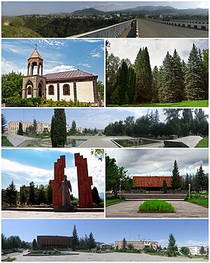
From top left:
Panoramic view of Stepanavan Surp Sarkis Church • Stepanavan Dendropark Downtown Stepanavan Memorial to Stepan Shaumian • Stepan Shaumian Museum Stepanavan central square |
||
|
||
| Coordinates: 41°00′34.65″N 44°23′2.71″E / 41.0096250°N 44.3840861°ECoordinates: 41°00′34.65″N 44°23′2.71″E / 41.0096250°N 44.3840861°E | ||
| Country |
|
|
| Marz | Lori | |
| Founded | 1810 | |
| Government | ||
| • Mayor | Sarkis Gharakeshishian | |
| Area | ||
| • Total | 14 km2 (5 sq mi) | |
| Elevation | 1,375 m (4,511 ft) | |
| Population (2011 census) | ||
| • Total | 13,086 | |
| • Density | 930/km2 (2,400/sq mi) | |
| Time zone | GMT +4 (UTC+4) | |
| Website | Official website | |
| Sources: Population | ||
Stepanavan (Armenian: Ստեփանավան), is a town in the Lori Province of Armenia. It is located 139 km north of the capital Yerevan and 24 km north of the provincial centre Vanadzor, in the centre of Yerevan-Tbilisi highway. As of the 2011 census, the population of the town is 13,086. Due to its location on the shores of Dzoraget River among the forest of Lori plateau and Bazum mountains, Stepanavan is considered a resort town in northern Armenia.
Stepanavan was founded in 1810 as Jalaloghli, literally meaning son of Jalal in Turkic languages. The name is derived from the Armenian noble family of Hasan-Jalalyan. A khachkar-memorial in the town testifies that the settlement was founded in 1810 by prince Davit Hasan-Jalalyan. In 1923, Jalaloghli was renamed Stepanavan, meaning town of Stepan in Armenian, in honour of the bolshevik leader Stepan Shaumian.
The area of modern-day Stepanavan was first settled during the 4th millennium BC. The remains of an ancient fortress is found in the western edge of the town dating back to the 3rd millennium BC. Later, it became part of the Urartu Kingdom between the 8th and 6th centuries BC. After the Achaemenid invasion, the region became part of the Satrapy of Armenia between the 6th and 4th centuries BC. With the establishment of the Kingdom of Armenia in 331 BC, the region became part of the Tashir canton of the historic Gugark province, the 13th province of Greater Armenia.
Following the partition of Armenia in 387 between the Byzantine Empire and Sassanid Persia, and the subsequent collapse of Arsacid Armenia in 428, Eastern Armenia including Tashir region became under the rule of Sassanid Persia. However, the earliest records about human settlement in modern-day Stepanavan dates back to the 5th century, when the basilica of the Holy Mother of God was built on the shores of Dzoraget River (destroyed by the Soviets during the 1930s).
...
Wikipedia


