State Route 5 and US 20
| New York State Route 5 | ||||
|---|---|---|---|---|

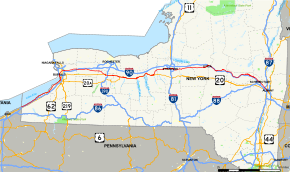
Map of New York with NY 5 highlighted in red
|
||||
| Route information | ||||
| Maintained by NYSDOT and the cities of Buffalo, Syracuse, Utica, Amsterdam, Schenectady, and Albany | ||||
| Length | 370.80 mi (596.74 km) | |||
| Existed | 1924 – present | |||
| Major junctions | ||||
| West end |
|
|||
| East end |
|
|||
| Location | ||||
| Counties | Chautauqua, Erie, Genesee, Livingston, Ontario, Seneca, Cayuga, Onondaga, Madison, Oneida, Herkimer, Montgomery, Schenectady, Albany | |||
| Highway system | ||||
|
||||
New York State Route 5 (NY 5) is a state highway that extends for 370.80 miles (596.74 km) across the state of New York in the United States. It begins at the Pennsylvania state line in the Chautauqua County town of Ripley and passes through Buffalo, Syracuse, Utica, Schenectady, and several other smaller cities and communities on its way to downtown Albany in Albany County, where it terminates at U.S. Route 9 (US 9), here routed along the service roads for Interstate 787 (I-787). Prior to the construction of the New York State Thruway, it was one of two main east–west highways traversing upstate New York, the other being US 20. West of New York, NY 5 continues as Pennsylvania Route 5 (PA 5) to Erie.
NY 5 overlaps with US 20 twice along its routing. The second, a 68-mile (109 km) overlap through western and central New York, is the second-longest concurrency in the state, stretching from Avon east to the city of Auburn in Cayuga County. The concurrency is known locally as "Routes 5 and 20". As the route proceeds across the state, it also directly or indirectly meets every major north–south highway in upstate New York, including all three north–south Interstate Highways (I-390 in Avon, I-81 in Syracuse via US 11, and I-87 in Albany).
...
Wikipedia

