Stark, New Hampshire
| Stark, New Hampshire | |
|---|---|
| Town | |
 |
|
 Location in Coos County, New Hampshire |
|
| Coordinates: 44°36′05″N 71°24′33″W / 44.60139°N 71.40917°WCoordinates: 44°36′05″N 71°24′33″W / 44.60139°N 71.40917°W | |
| Country | United States |
| State | New Hampshire |
| County | Coos |
| Incorporated | 1795 |
| Government | |
| • Board of Selectmen | Albert Cloutier, Jr., Chair Colin Wentworth Lisa Demers |
| Area | |
| • Total | 59.6 sq mi (154.3 km2) |
| • Land | 58.7 sq mi (152.0 km2) |
| • Water | 0.9 sq mi (2.4 km2) 1.52% |
| Elevation | 964 ft (294 m) |
| Population (2010) | |
| • Total | 556 |
| • Density | 9.3/sq mi (3.6/km2) |
| Time zone | Eastern (UTC-5) |
| • Summer (DST) | Eastern (UTC-4) |
| ZIP code | 03582 |
| Area code(s) | 603 |
| FIPS code | 33-73060 |
| GNIS feature ID | 0873724 |
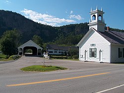
Stark is a town in Coos County, New Hampshire, United States. The population was 556 at the 2010 census. It has a famous covered bridge. The town includes the villages of Percy and Crystal as well as the village of Stark, located on the Upper Ammonoosuc River. New Hampshire Route 110 runs through Stark, east from U.S. Highway 3 in Groveton and northwest from Route 16 in Berlin. Much of the town is within the boundaries of the White Mountain National Forest.
Stark is part of the Berlin, NH–VT Micropolitan Statistical Area.
Granted in 1774, Stark was originally named Percy, after Hugh Percy, 1st Duke of Northumberland. The town was incorporated in 1795, and renamed Stark in 1832, after General John Stark, author of New Hampshire's motto, "Live Free or Die".
In early 1944, the remains of a former Civilian Conservation Corps camp in the town were converted to form Camp Stark, which would hold about 250 German POWs. This was the only World War II POW camp located in New Hampshire. Most of the men in the camp performed hard labor in the nearby forests, supplying wood for the paper mills in Berlin, New Hampshire. Some of the men eventually came back to live in the United States and Canada after the war ended, and the camp was closed in 1946.
...
Wikipedia
