Star City, Arkansas
| Star City, Arkansas | |
|---|---|
| City | |

Clock tower on the town square
|
|
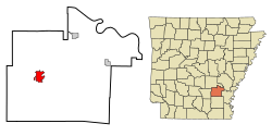
 Location in Lincoln County and the state of Arkansas |
|
| Coordinates: 33°56′27″N 91°50′33″W / 33.94083°N 91.84250°WCoordinates: 33°56′27″N 91°50′33″W / 33.94083°N 91.84250°W | |
| Country | United States |
| State | Arkansas |
| County | Lincoln |
| Area | |
| • Total | 4.2 sq mi (10.9 km2) |
| • Land | 4.2 sq mi (10.9 km2) |
| • Water | 0 sq mi (0 km2) |
| Elevation | 272 ft (83 m) |
| Population (2000) | |
| • Total | 2,471 |
| • Density | 588.3/sq mi (226.7/km2) |
| Time zone | Central (CST) (UTC-6) |
| • Summer (DST) | CDT (UTC-5) |
| ZIP code | 71667 |
| Area code(s) | 870 |
| FIPS code | 05-66440 |
| GNIS feature ID | 0078447 |
Star City is a city in and the county seat of Lincoln County, Arkansas. Incorporated in 1876, the city is located between the Arkansas Delta and Arkansas Timberlands. With an economy historically based on agriculture, today Star City has developed a diverse economy based on both industry and agriculture. As of the 2010 census, the population was 2,274. Star City is located within the Pine Bluff metropolitan area.
Star City is located at 33°56′27″N 91°50′33″W / 33.94083°N 91.84250°W (33.940947, -91.842575).
According to the United States Census Bureau, the city has a total area of 4.2 square miles (11 km2), all of it land.
The city is between Monticello and Pine Bluff.
As of the census of 2000, there were 2,471 people, 875 households, and 603 families residing in the city. The population density was 587.5 people per square mile (226.6/km²). There were 972 housing units at an average density of 231.1 per square mile (89.1/km²). The racial makeup of the city was 76.93% White, 21.08% Black or African American, 0.61% Native American, 0.04% from other races, and 0.77% from two or more races. 1.21% of the population were Hispanic or Latino of any race.
...
Wikipedia
